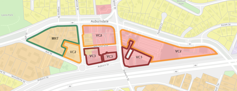
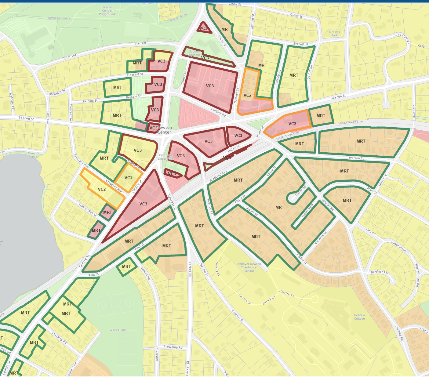
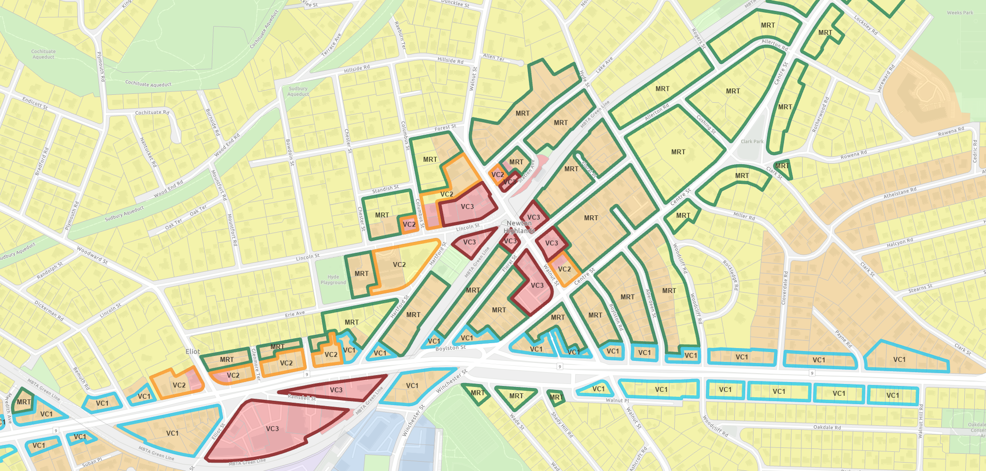
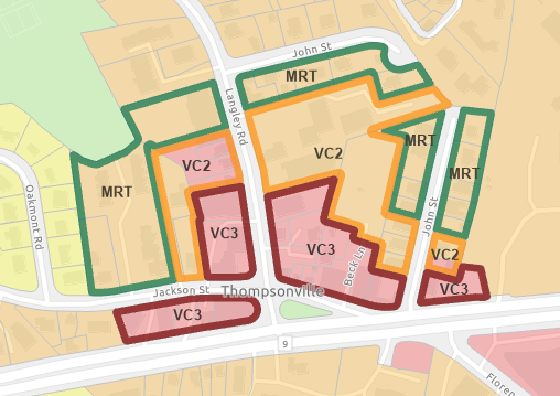
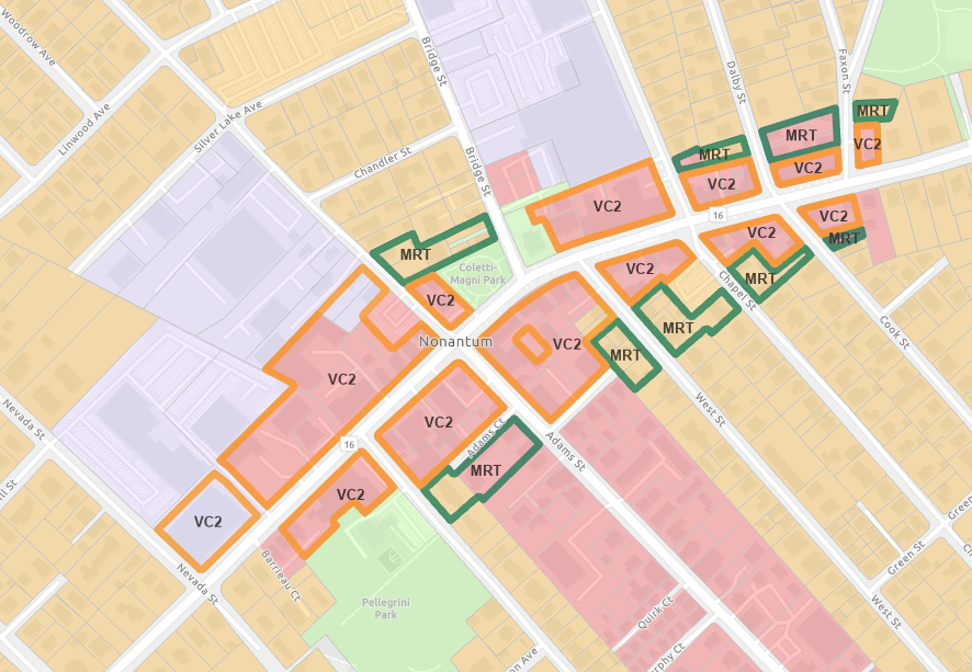
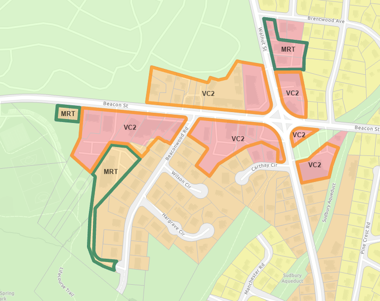
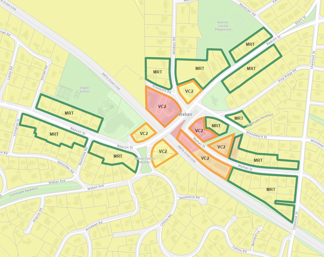
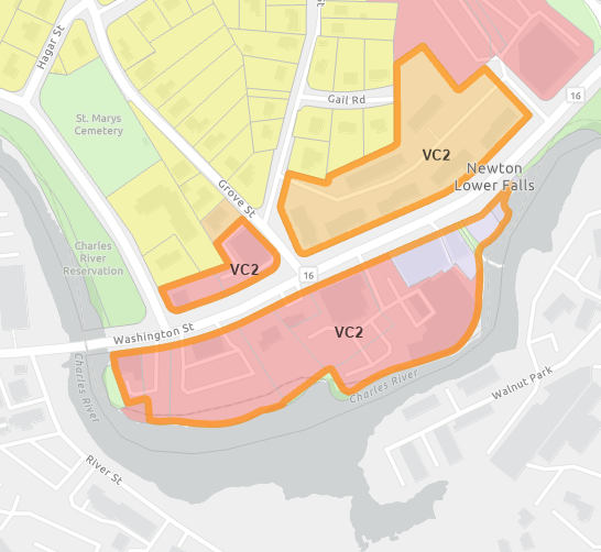
Thoughts on Newton Village Center Zoning Version 2
and
MBTA Communities Zoning
Prepared by Richard Rasala r.rasala@gmail.com
Posted on August 17 2023
The Executive Office of Housing and Livable Communities (EOHLC) posted an update to the MBTA Compliance Guidelines on 2023-08-17 which is the same date that I posted this document. The links are here:
Revision #1 Posted on September 12 2023
The new material is posted primarily in the sections:
A small amount of additional material has been added to the MRT related sections.
Although this document might be read straight through, a more fruitful approach might be to use the Contents below to jump to the location that you wish to read next.
To facilitate this approach, I have sprinkled links Go to Top throughout the document so that you may go back to the top of this page as you wish.
Note: If you click on any image, the image will open in a separate tab. On a large screen, this will often let you see a wider version of the image and will let you zoom in to examine details.
Cover Letter to the Original Post of August 17 2023
Cover Letter to Revision #1 of September 12 2023
Contents
- Introduction
- Zoning Web Sites created by Richard Rasala
- Document Links: Village Center Zoning & MBTA Communities Zoning
- Constraints on Setting Up Districts for MBTA Compliance Zoning
- Discussion of Village Center Zoning Version 2 and MBTA Communities Zoning
-
- Recap of our earlier Discussion of Village Center Zoning Version 1
- Issues with Village Center Zoning Version 2 and MBTA Communities Zoning
- What zoning policies are being followed in the VCOD Version 2.0/2.1 proposal?
- Recommendation: Eliminate the Route 9 District
- Recommendation: Eliminate VC1 as a Zoning Category
- Discussion of Excerpts from the VCOD Version 2.1 Zoning Code
- Mellow Zoning for MRT
- The Large Contiguous MRT District in the 5 Half Mile Circles
-
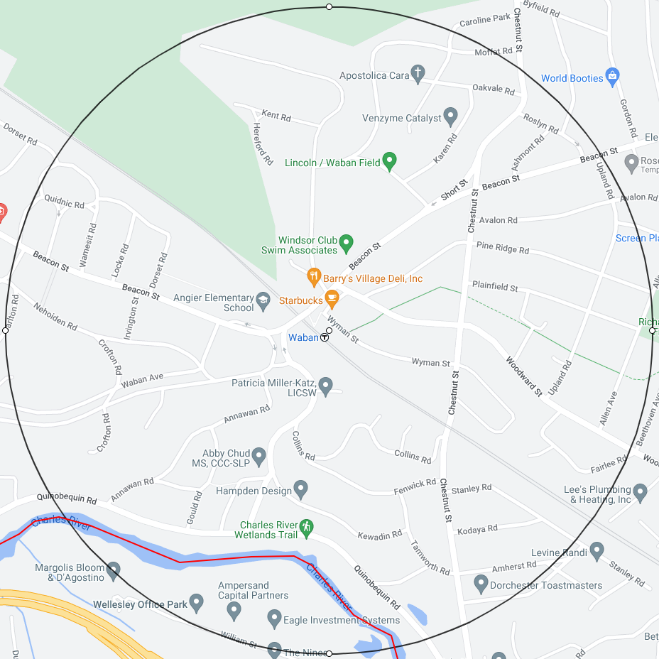
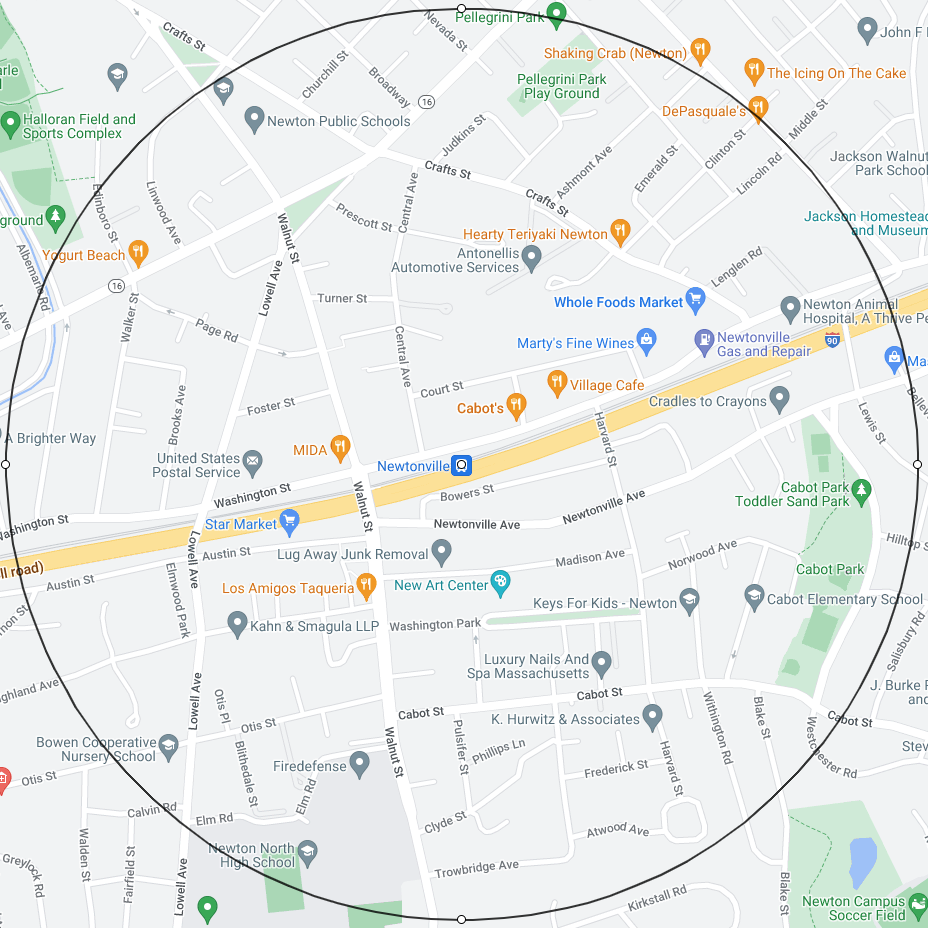
- The 11 Half Mile Circles at Rail Transit Stops in Newton
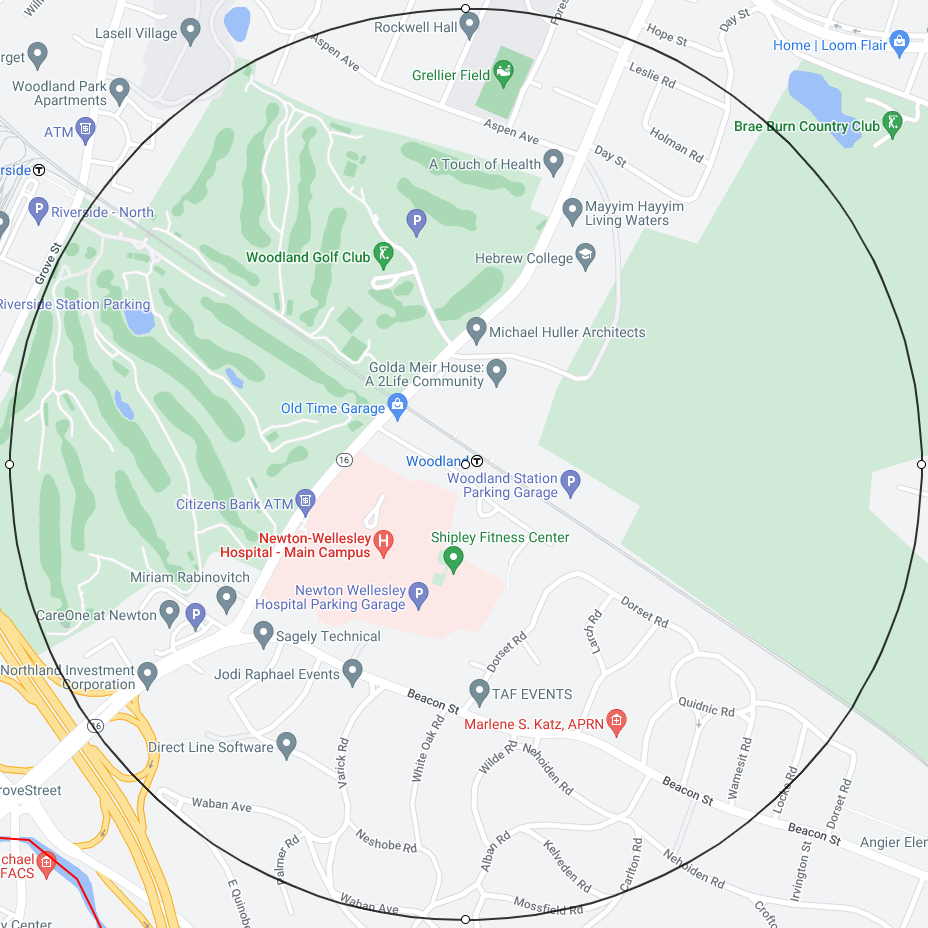
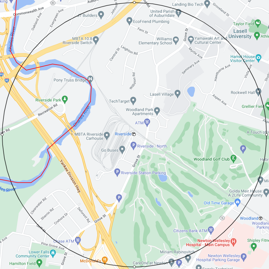
- The 5 Half Mile Circles for the Large Contiguous MRT District
- 16 Contiguous Backbone Paths in the 5 Half Mile Circles
- The Large Contiguous MRT District and the Completion of MBTA Communities Zoning
- MRT-A = MRT plus the Ability to have Small Apartment Buildings
- An additional zoning type to assist in the Completion of MBTA Communities Zoning
- Final Thoughts on Village Center Zoning
- Coda: A Summary of Important Points
- From time to time, you may wish to consult the maps in these appendices:
- Appendix: Village Center and Route 9 Proposed Zoning Maps Version 2
- Village Centers With VC2 and VC3
- Village Centers With VC2 Only
- Route 9
- Planning Dept Large Contiguous MBTA District
- Appendix: Half Mile Circle Maps at Rapid Transit & Commuter Rail T Stops
- Green Line B Branch
- Green Line D Branch
- Commuter Rail
- 11 Half Mile Circles
- Appendix: Newton Historic Districts
Introduction
This introduction will conclude with a list of my most important recommendations. The list will permit you to see where the document is heading. The introduction will start with a condensed discussion of why the recommendations should be implemented. More detailed discussion will follow in the document.
The basis for the recommendations is:
- A detailed study of what has transpired in the Zoning and Planning Committee since 2020:
- Newton MA Zoning Documents
- A detailed study of the reality of transit in Newton:
- The Reality of Transit in Newton
For a brief synopsis of the transit reality study, see:
Contents of the Introduction
- The Emphasis of Village Center Zoning versus the Emphasis of the MBTA Communites Law
- The VCOD Version 2 Approach to MBTA Communites Zoning
- The MRT Only Approach to MBTA Communites Zoning
- Make VCOD Zoning Less Intense and Less Dense
- Important Recommendations
The Emphasis of Village Center Zoning versus the Emphasis of the MBTA Communites Law
In many ways, it is unfortunate that the city of Newton had the ongoing project of Village Center Zoning underway when the MBTA Communites Law was passed in 2022.
The emphasis of Village Center Zoning is intense dense zoning on a very small percentage of the land area of Newton.
The emphasis of the MBTA Communites Law is to promote the rezoning of single family districts into districts that permit homes with 3 or 4 family units. These multi-family homes should be buildable by right either by adaptive reuse of an existing single family home or by new construction. Although it is also possible in MBTA zoning to provide housing units in large apartment style buildings, that is not the primary mindset and intention of the MBTA Communites Law.
The Village Center Zoning and the MBTA Communites Law really have quite disparate goals.
The VCOD Version 2 Approach to MBTA Communites Zoning
If Village Center Zoning had not existed when the MBTA Communites Law was passed in 2022, it is hard to believe that anyone would have invented Village Center Zoning as the means to solve the zoning requirements posed by the MBTA Communites Law.
If seems that, for the Planning Dept, the Village Center Zoning plan was a tool in the tool shed and the inclination was to utilize that tool rather than to think about the MBTA Communites Law with fresh eyes.
Here is what has happened by the application of the Village Center Zoning tool to the MBTA Communites Law zoning problem. The VCOD proposal of April 24, 2023 (VCOD Version 2) creates the lion's share of its 10000 housing units by using primarily large apartment style buildings in the zoning areas listed:
- The intense dense V2 and V3 area in West Newton [1850 units]
- The intense dense V2 and V3 area plus some moderate MRT area in Newton Centre [2000 units], Newton Highlands [1650 units], and Newtonville [1400 units]
- The extremely intense dense VC1, VC2, and VC3 area in a new long and narrow Route 9 district [2600 units]
The only genuinely moderate zoning area is:
- The VC2 and MRT area in Waban [500 units]
See the map:
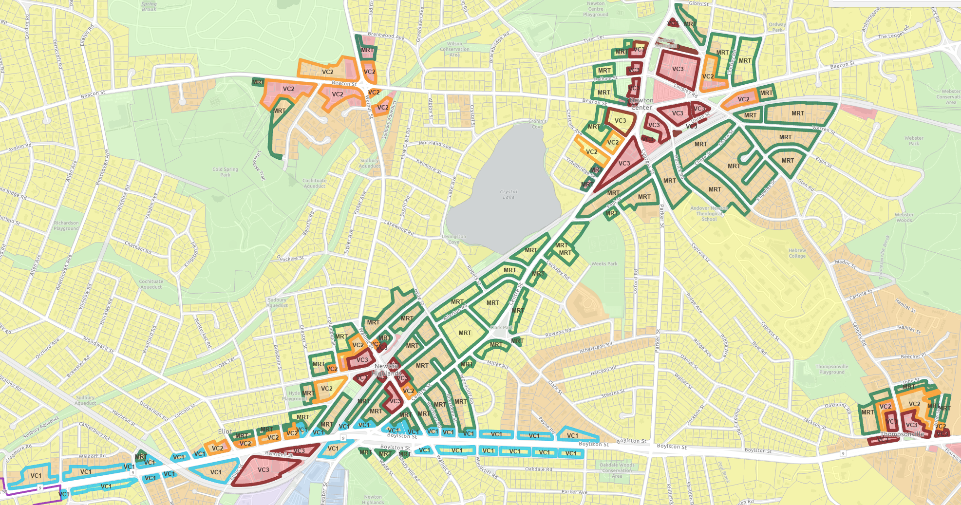
MBTA Compliance Map Version 2
There is some sprinkling of MRT lots in all 6 zoning areas above and these do contribute to some degree to the total of housing units for MBTA compliance.
However, the most important role of MRT in this VCOD based proposal is to glue Newton Centre to Newton Highlands along Centre St from Paul St to Hyde St.
Without this MRT glue, the Planning Dept would be unable to create the large contiguous district required by the MBTA Communites Law.
The glue path along Centre St from Paul St to Hyde St sets an important precedent:
It is appropriate for the multi-family MRT overlay district to overlay a Single Residence 2 (SR2) District or Single Residence 3 (SR3) District.
See the maps:
Planning Dept Large Contiguous MBTA District Version 2
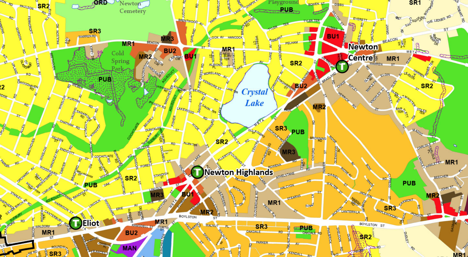
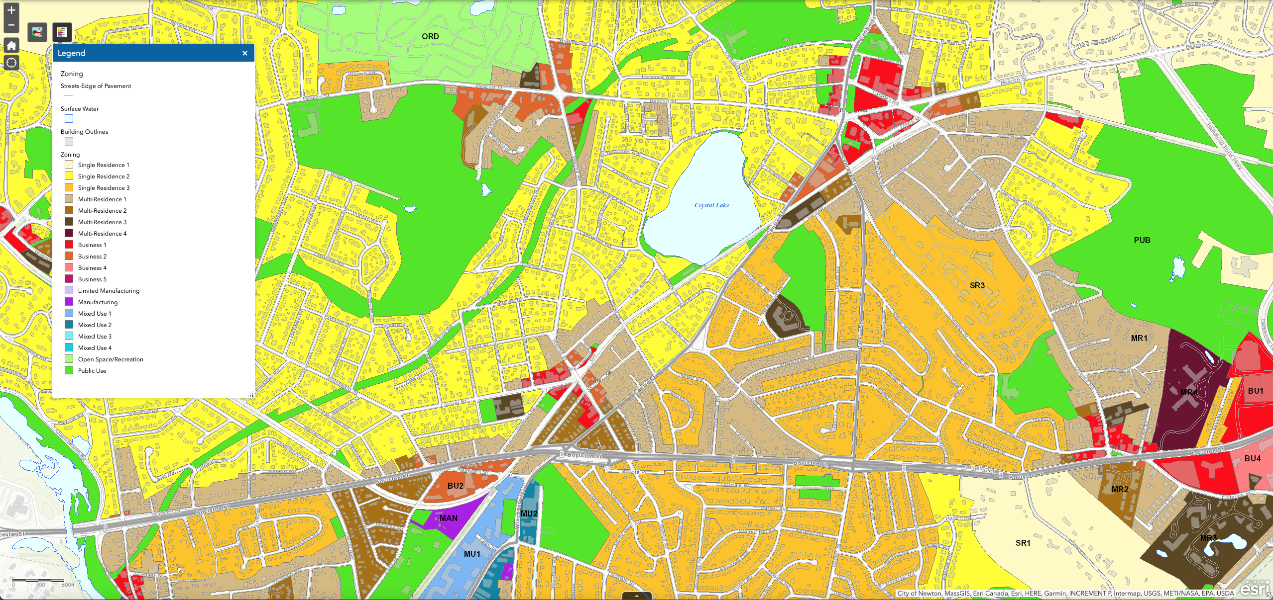
Current Newton Zoning Under Planning Dept Large Contiguous MBTA District
What the above maps show is that:
The multi-family MRT district along Centre St from Paul St to Hyde St overlays an SR2 district to the west of Centre St and overlays an SR3 district to the east of Centre St.
The Planning Dept cannot take back the precedent that:
It is appropriate for the multi-family MRT overlay district to overlay a Single Residence 2 (SR2) District or Single Residence 3 (SR3) District.
Should the Planning Dept consider a reversal, it then would be unable to create the large contiguous district required by the MBTA Communites Law.
This precedent will be useful as the discussion goes forward.
I believe strongly that the attempt to satisfy the MBTA Communites Law using VCOD Version 2 is entirely the wrong approach.
- The decision to create a substantial portion of the 10000 housing units for MBTA Compliance via the mechanism of intense dense buildings in the village centers undermines the intentions of the MBTA Communities Law to promote 3-4 family homes in residential areas.
- The proposal for intense dense buildings in the village centers also raises serious concerns with the public since that the plan is not the vibrant vision with moderate height buildings, plazas, walkable areas, and bicycle paths that is promoted in the Village Center Zoning slides.
Let me discuss in the next section a much better approach based entirely on MRT zoning.
The MRT Only Approach to MBTA Communites Zoning
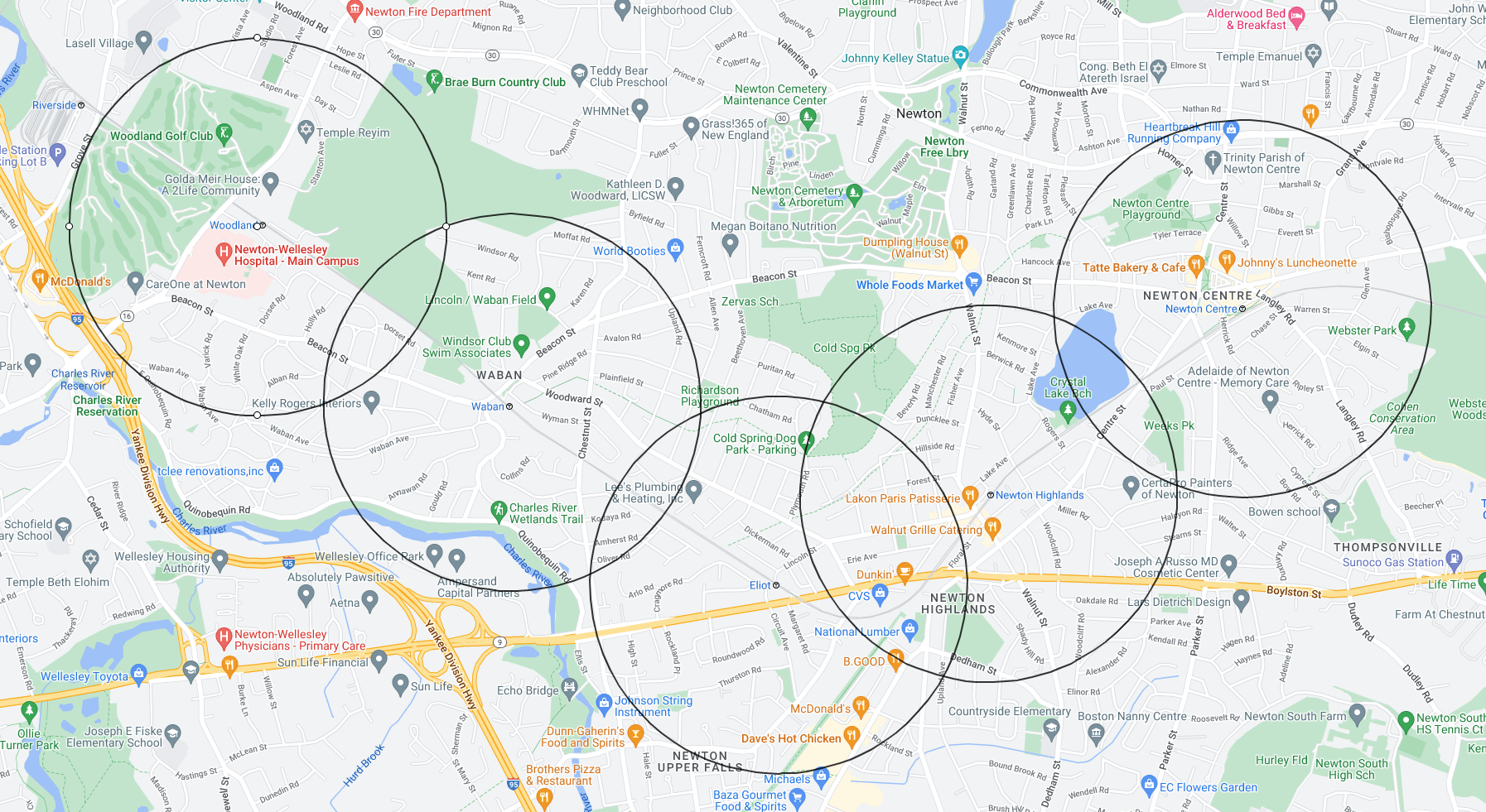
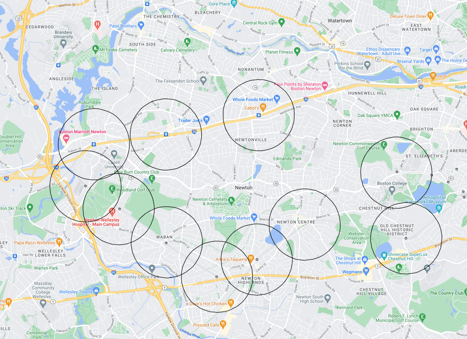
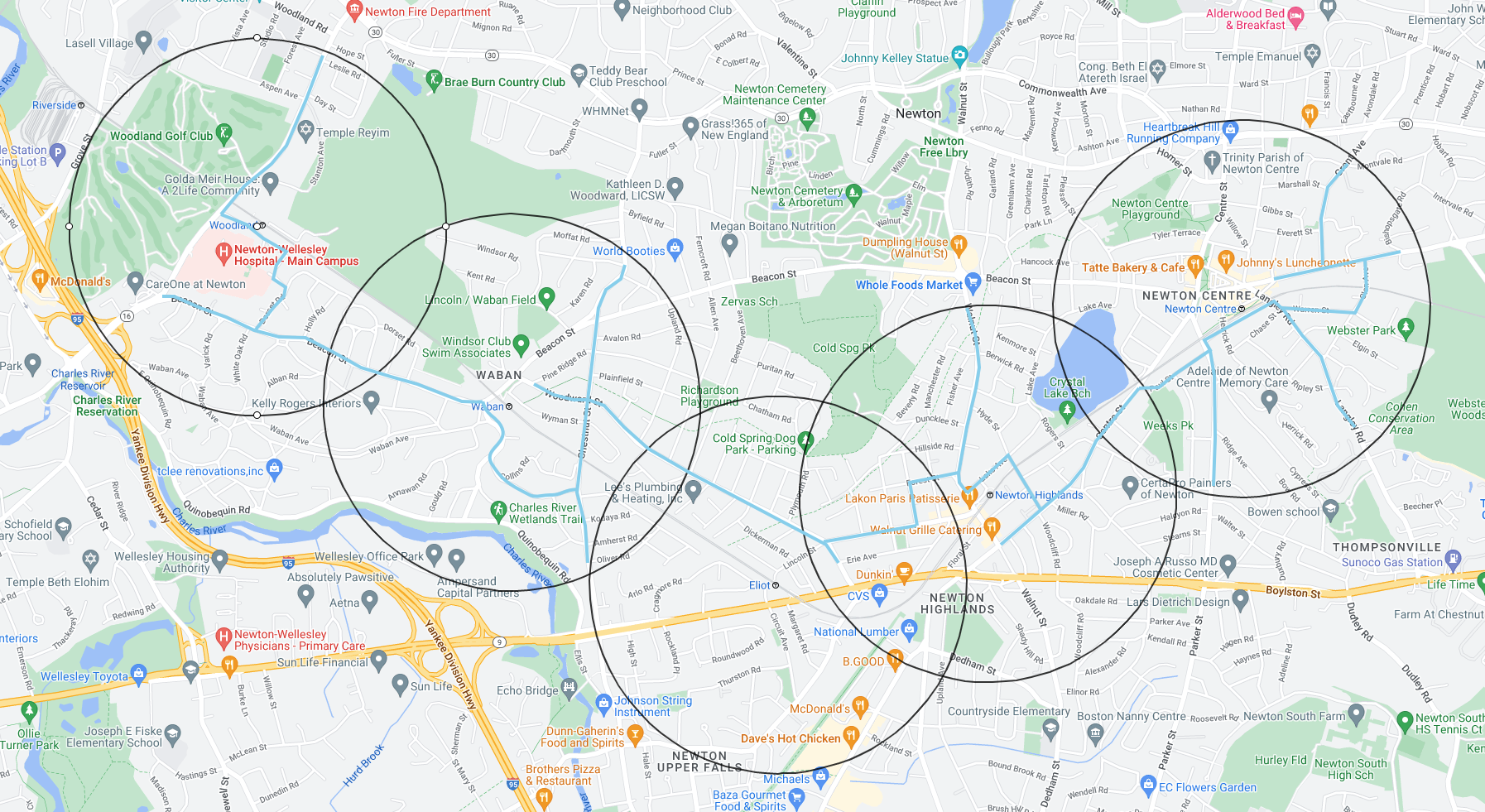
I propose that Newton use MRT to satisfy the MBTA Communites Law in one specific contiguous area, namely, in the contiguous residential areas of the 5 half mile circles at Newton Centre, Newton Highlands, Eliot, Waban, and Woodland. This MRT zoning may be called MBTA Communites Zoning.
The 5 Half Mile Circles
The reasons for choosing the 5 half mile circles for the MRT contiguous zone are:
- The area is almost certainly large enough to meet all MBTA Communites Law requirements.
- The Green Line D Branch (Riverside) has the only high quality intra-city transit in Newton. - As the reality of transit study shows, all other Newton transit options are problematic at best for families with children.
I propose that MRT zoning may be an overlay district on top of the following current zones:
- Single Residence 2 (SR2)
- Single Residence 3 (SR3)
- Multi Residence 1 (MR1)
- Multi Residence 2 (MR2)
- Multi Residence 3 (MR3)
In fact, in the Planning Dept’s VCOD zoning discussed in the previous section, there actually is a precedent for the use of MRT as an overlay over all five of these zones.
The process for the creation of the contiguous residential area that will need to be zoned MRT is discussed in depth below:
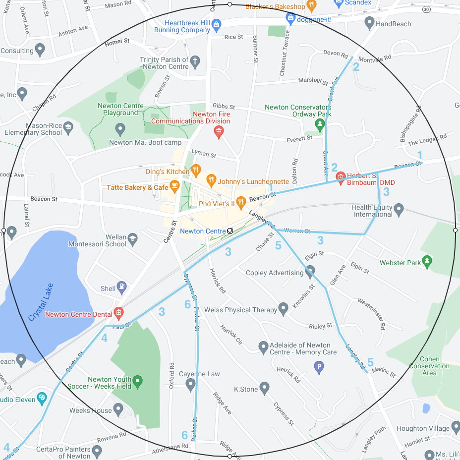
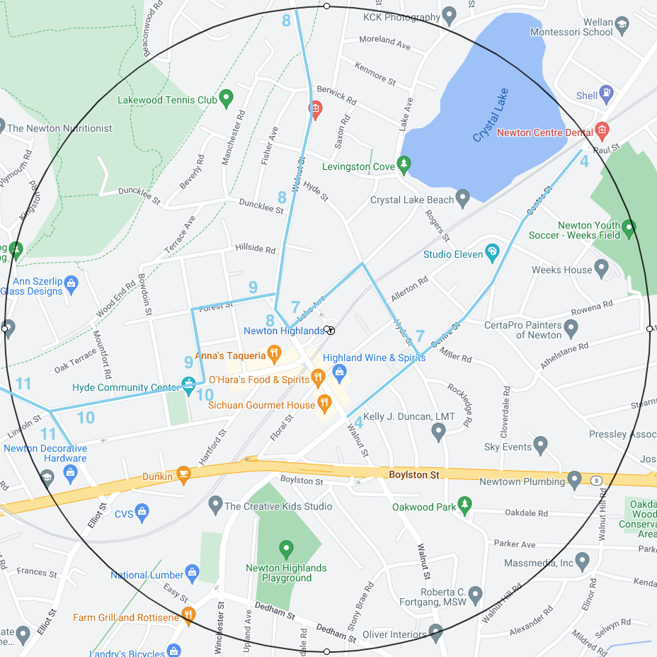
The key idea will be to create a long contiguous backbone path through the 5 half mile circles and then spread the MRT zoning to the residential lots that may be connected by steps to the backbone.
This process of spreading may stop when the magic number of 8330 enabled housing units is reached or it may continue as far as it can go. The latter approach may actually be preferable so that it will be clear on a map exactly what area is zoned MRT.
I now assert:
It is absolutely imperative that the type of housing permitted by MRT be acceptable in Newton, especially, when the MRT overlay district is above a single residence district.
This where the ideas of Daniel Parolek about Missing Middle Housing are relevant:
Parolek’s ideas are also explained in greater depth in his book Missing Middle Housing.
Parolek and his company Opticos Design have worked for 20+ years on the concepts and the nitty gritty details of how to smoothly integrate multi-family housing into single family districts in as seamless a fashion as possible.
For an approach to adapting Daniel Parolek’s ideas to the context of Newton, see the discussion below:
It is my belief that Parolek’s ideas should alleviate the concerns of Newton residents about multi-family MRT overlays above single residence districts.
I am therefore hopeful that people in Newton will give the idea of an MRT district in the 5 half mile circles serious consideration.
- It is the only way to provide families with children an opportunity to live in 3-4 family homes.
- It is also the only way to relieve the density pressure on our village centers and make the village centers both more vibrant and more livable.
Make VCOD Zoning Less Intense and Less Dense
These recommendations for VCOD Zoning assume that the implementation of the MBTA Communities Law will be handled separately by MRT zoning of the residential areas of the 5 half mile circles, that is, by what I have called MBTA Communities Zoning.
This means that VCOD Zoning should be placed on hold until MBTA Communities Zoning is complete. MBTA Communities Zoning should go much faster than VCOD since it is less complex.
Given MBTA Communities Zoning, it is no longer imperative that VCOD carry the burden of lots and lots of housing in the village centers.
The goal of VCOD may return to the original vision of vibrant and livable villages with moderate height buildings, plazas, walkable areas, and bicycle paths, that is, the vision promoted in the Village Center Zoning slides.
I will list some VCOD recommendations with bullet points and comments.
- Eliminate VC1.
- Use MRT for all residential needs in or near a village center.
This just makes sense. MRT should be the gold standard for how to zone a residential lot so that what is built will fit in as seamlessly as possible into the neighborhood.
- The city should live with its original height specifications of VC2 = 3.5 stories and VC3 = 4.5 stories.
I live in Newton Corner. The tall buildings in the Circle of Death do not contribute to the vibrancy of Newton Corner as a village. Instead the tall buildings split Newton Corner into two communities (north side and south side) that rarely have in person contact and that communicate with difficulty. The people who live in the rest of Newton should view Newton Corner as a cautionary tale that warns: Excess height should not be allowed to happen in any village center.
There should be absolutely no notion of a height bonus in VCOD. Not for affordable housing percentages. Not for any other good purpose.
- The city should require a special permit for buildings in VC2 and VC3.
The quality of the large buildings in the village centers is vital to the community and therefore to the success or failure of the entire village center project. If buildings are poorly designed and/or constructed, this will become a blight on the village centers for decades. The city must take a hands on approach to what is proposed in the village centers. The mechanism for this is special permit review.
- The city should seriously consider whether VC3 is needed at all.
A question to ask in parallel is:
- On a village by village basis, how much housing is directly needed in the village and how much of this housing may be supplied by VC2 in the center and MRT nearby?
With a minimum of 8330 housing units enabled in MBTA Communities Zoning in the 5 half mile circles, Newton does not need the amount of housing envisioned in the village centers in VCOD Version 2. The village centers do not have the burden of providing for much of the housing needs of Newton. Thus, from a housing standpoint, it is quite unclear why Newton needs 4.5 story buildings in village centers.
If the Zoning and Planning Committee and the Planning Dept believe that VC3 may be necessary then they should produce data estimates, village by village, of:
- How many housing units will be produced on the VC2 lots?
- How many housing units will be produced on the VC3 lots if zoned as VC3?
- How many housing units will be produced on the VC3 lots if down-zoned instead to VC2?
- Should VC3 lots be down-zoned to VC2 lots:
-
- Why would this loss of housing be critical to the village?
- Can extra MRT zoning around the village make up for some or all of this loss of housing?
Having this data will help both those in city goverment and ordinary citizens decide what is best to do.
Important Recommendations
- MBTA Communities Zoning should be separated from the more complex Village Center Zoning.
- MBTA Communities Zoning should probably have its own City Council docket number.
- MBTA Communities Zoning should be finished on time in 2023.
- MBTA Communities Zoning should be based 100% on MRT zoning.
- MRT zoning should adapt the ideas of Daniel Parolek in Missing Middle Housing so that the multi-family housing that is built under MRT fits in seamlessly with adjacent single-family housing.
- MRT zoning may be an overlay district on top of the following current zones:
-
- Single Residence 2 (SR2)
- Single Residence 3 (SR3)
- Multi Residence 1 (MR1)
- Multi Residence 2 (MR2)
- Multi Residence 3 (MR3)
- The large contiguous district of zoned area that is required by MBTA Communities Zoning should entirely use MRT zoning and should be designed to overlay much of the residential area in the 5 half mile circles around the transit stations of Newton Centre, Newton Highlands, Eliot, Waban, and Woodland.
- The justification for this choice for the large contiguous district is that the Green Line D Branch (Riverside) has by far the best intra-city transit in Newton.
- One major purpose of this document is to show via maps how to accomplish the task of creating the large contiguous district.
- Eliminate VC1.
- Village Center Zoning should use the MRT zone defined for MBTA Communities Zoning for its residential areas.
- The city should live with its original height specifications of VC2 = 3.5 stories and VC3 = 4.5 stories.
- The city should require a special permit for buildings in VC2 and VC3.
- The city should seriously consider whether VC3 is needed at all.
- On a village by village basis, how much housing is directly needed in the village and how much of this housing may be supplied by VC2 in the center and MRT nearby?
- Eliminate the intense Route 9 district that uses VC1, VC2, and VC3.
- It is OK to zone the residential lots north of Route 9 that fall into the half mile circles with MRT zoning.
- There should be no zoning south of Route 9 associated with either MBTA Communities Zoning or Village Center Zoning.
- The affordable housing percentage in VC zones should be identical to the city wide percentage, currently, 17%. There should be no concept of granting a height bonus in exchange for an increase in the affordable housing percentage.
- The timeline for completion of Village Center Zoning may be late 2023. But there is no harm if this timeline slips into 2024 since MBTA Communities Zoning will not depend on Village Center Zoning.
- Due to the significant service limitations of existing MBTA transit and its inadequacies for use by parents traveling with children, there should be minimum parking requirements associated with the number of housing units in a project:
-
- MRT zoning should require a minimum of one car parking space per housing unit in each home.
- In VC2 and VC3, the minimum number of parking spaces associated with the housing component of a project should be 2/3 of the number of housing units in the project.
- The city should use the special permit process to have dialogs with developers about how much public parking will be needed to enable people from the entire city to utilize the businesses in the mixed use buildings.
- There is no formula for this. There needs to be mutual discussion.
Zoning Web Sites created by Richard Rasala
On the above web site, I have collected all Newton MA zoning materials since January 2020. This site consists almost entirely of links to data documents. There are a few links to related documents or sites.
To find more information about Village Center Zoning and MBTA Communities Zoning in Newton, you may search on this site for: “village center”, “vc”, and “mbta”.
On the above web site, I have collected selected Newton MA historical zoning materials published prior 2020. The selection was based on references to these older documents in recent zoning documents.
The above web site is a web document that does an analysis of village center zoning version 1.
The above web site is a web document that collects for comparison slide images taken from the Planning Dept presentations for village center zoning versions 1 and 2. The MBTA slides are included as well
The above web site is a web document that performs a deep dive into the level of MBTA service in Newton based on the final 2022 MBTA schedules and based on the reality of the problems that have plagued the MBTA throughout 2023.
Excerpts from The Reality of Transit in Newton
The need for families to be able to move about Newton
The data in this transit document shows that families especially families with children cannot rely on existing public transit to meet their family’s needs. Using the words transit-oriented is simply waving a verbal magic wand. Saying these words cannot change the reality of transit in Newton.
The only quality intra-city transit in Newton is the Green Line D Branch (Riverside). All other transit routes have problematic intra-city transit or no intra-city transit whatever.
The purpose of the MBTA Communities Law is to enable housing for families especially families with children. Our goal as a city should be not only to enable the building of housing units where such families may live (dwell) but also to enable such families to have a life in Newton as a city. This requires that these families be able to move about Newton conveniently.
Implications for MRT Zoning
For most families the ability to move conveniently requires the ability to own at least one car. Walking or biking or public transit will not get a family everywhere conveniently. The decision to own a car or to manage by using alternatives that require a car (taxi, ride share, car rental, etc) is a decision that should be made by the family. The decision should not be made by a Newton zoning law that will permit 3-unit and 4-unit family homes to be built with no requirement for parking.
Therefore:
- MRT zoning should require a minimum of one car parking space per housing unit in each home.
Implications for VC2 and VC3 Zoning
Let me discuss:
- What should the minimum parking requirements be related to units in apartment style housing?
I am aware that people who have studied parking in apartment style housing know that there can be too much parking allocated and that the excess parking will never be used. I suspect that one car parking space per housing unit may be too much for apartments. So, the question is how to find the right parking formula?
I have studied the West Newton Armory Affordable Housing Project. The data may be found here.
The West Newton Armory Project design calls for:
- 43 housing units
- 28 car parking spaces
- 43 bike storage spaces
In this example, the number of car parking spaces is 2/3 of the number of housing units.
I think that 2/3 is a reasonable fraction to use as a parking guideline so I recommend:
- In VC2 and VC3, the minimum number of parking spaces associated with the housing component of a project should be 2/3 of the number of housing units in the project.
I certainly think that the ratio of (parking spaces) to (housing units) in a regular apartment project should not be less than that being specified for the West Newton Armory Affordable Housing Project.
Final Remarks
One thing that is certain is that the MBTA transit system that we have in Newton in 2023 does not support a car free life style. It is irresponsible to base zoning decisions on an idealized transit system that does not exist now and that may never exist. Substantive changes to the MBTA will take years if such changes come at all. The zoning rules we make now must be based on the reality we see now and can reasonably project into the near future, that is, 5 to 10 years out.
Document Links: Village Center Zoning & MBTA Communities Zoning
The Village Center Version 1.0 original slides are at:
See also:
The Village Center Version 2.0 original slides are at:
See also:
Zoning Maps:
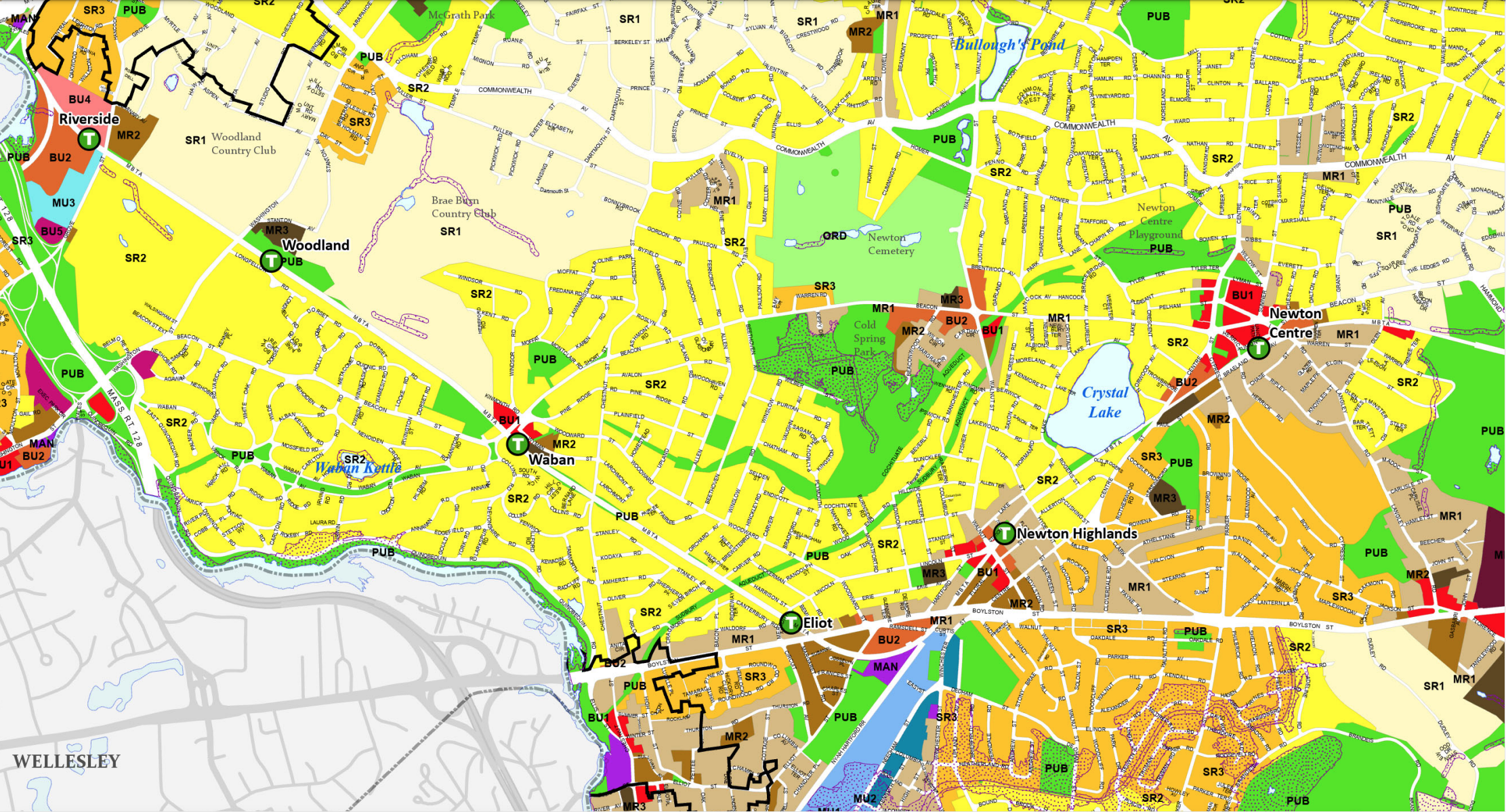
The map below will show the current zoning of Newton via zoning labels and color coding. The map is static.
The map below will show the current zoning of Newton via zoning labels and color coding. When zoomed, one may see zoning at the level of individual lots. However, one may not obtain data about the properties on the individual lots.
The map below will show multiple lots. If you search for an individual lot by address, you will obtain the data about the properties on that lot. However, there is no ability to do database queries to obtain summary information on multiple lots in a particular area.
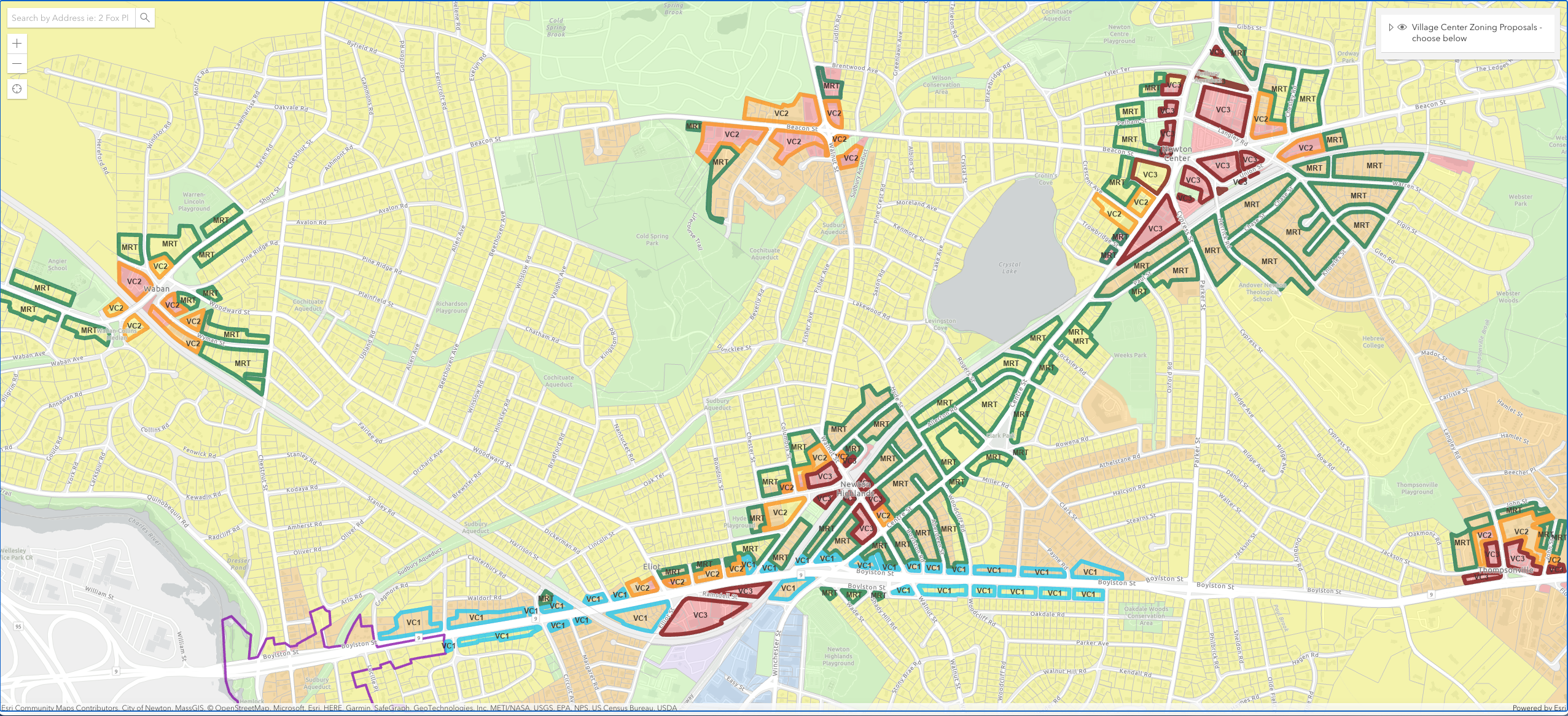
The map below will show either VCOD Version 1.0 zoning or VCOD Version 2.0 zoning.
If you load 2 copies of this map in separate tabs, you may set one copy for 1.0 and the other for 2.0. You may then switch between the maps to compare Version 1.0 and Version 2.0.
A much more interesting scenario is:
Load this map into a tab and set the VCOD Version to 2.0.
Then load the Current Newton Interactive Zoning Map into a separate tab.
You may then switch between the maps to see how VCOD Version 2.0 changes things compared to the current zoning.
West Newton Armory Project {for comparisons}
For information about the MBTA Communities Law, see:
Amy Dain series on MBTA Communities Law from Commonwealth magazine
A history of zoning in Newton and what kind of zoning do older adults need
Missing Middle Housing is a range of house-scale buildings with multiple units that are compatible in scale and form with detached single-family homes and that are located in a walkable neighborhood.
Constraints on Setting Up Districts for MBTA Compliance Zoning
If you are familiar with the MBTA Communities Law, you may wish to skip this section.
MBTA Compliance: Purposes, Definitions, and Rules
To set up MBTA Compliance Zoning, a city/town must define one or more multi-family housing districts that will satisfy the requirements of the MBTA Communities Law.
Each individual multi-family housing district must:
- Be a contiguous area that is at least 5 acres in size
- Be zoned to permit multi-family housing as defined by the MBTA Communities Law
To see what the second bullet means, let me extract some quotations from the 2202-08-10 document:
Here are the quotations:
“Housing suitable for families” means housing comprised of residential dwelling units that are not age-restricted housing, and for which there are no zoning restriction on the number of bedrooms, the size of bedrooms, or the number of occupants.
“Residential dwelling unit” means a single unit providing complete, independent living facilities for one or more persons, including permanent provisions for living, sleeping, eating, cooking and sanitation.
“Multi-family housing” means a building with 3 or more residential dwelling units or 2 or more buildings on the same lot with more than 1 residential dwelling unit in each building.
“Multi-family unit capacity” means an estimate of the total number of multi-family housing units that can be developed as of right within a multi-family zoning district, made in accordance with the requirements of section 5.b below.
“Multi-family zoning district” means a zoning district, including a base district or an overlay district, in which multi-family housing is allowed as of right; provided that the district shall be in a fixed location or locations, and shown on a map that is part of the zoning ordinance or by-law.
“As of right” means development that may proceed under a zoning ordinance or by-law without the need for a special permit, variance, zoning amendment, waiver, or other discretionary zoning approval.
The multi-family unit capacity is calculated as follows:
- To obtain the multi-family unit capacity of one individual multi-family housing district, the MBTA compliance tool adds up the number of possible housing units on each lot in the district based on the zoning rules defined by the city/town.
- To obtain the total multi-family unit capacity of the collection of multi-family housing districts, the MBTA compliance tool simply adds up the contribution from each individual district.
For Newton:
The total multi-family unit capacity is required to be at least 8330.
The number 8330 is computed by a formula based on the amount of housing currently in Newton.
Let the “total zoned land area” stand for the total land area in acres of the collection of multi-family housing districts that make up the district that is zoned for the MBTA Communities Law.
Then the “gross density” of the zoning plan is defined as:
gross density = (total multi-family unit capacity)/(total zoned land area)
The MBTA Compliance document says this in words:
“Gross density” means a units-per-acre density measurement that includes land occupied by public rights-of-way and any recreational, civic, commercial, and other nonresidential uses.
This wording is what mandates that the total zoned land area must include the area of the public roads in the zoned area.
The MBTA Compliance document requires that the gross density must be at least 15 units-per-acre.
MBTA Compliance: The Role of Half Mile Circles
The “half mile circles” centered at the rapid transit and commuter rail stops also play a large role in the MBTA Compliance requirements. The following definitions are relevant:
“Transit station” means an MBTA subway station, commuter rail station, ferry terminal or bus station.
“Transit station area” means the land area within 0.5 miles of a transit station.
“Developable station area” means developable land that is within 0.5 miles of a transit station.
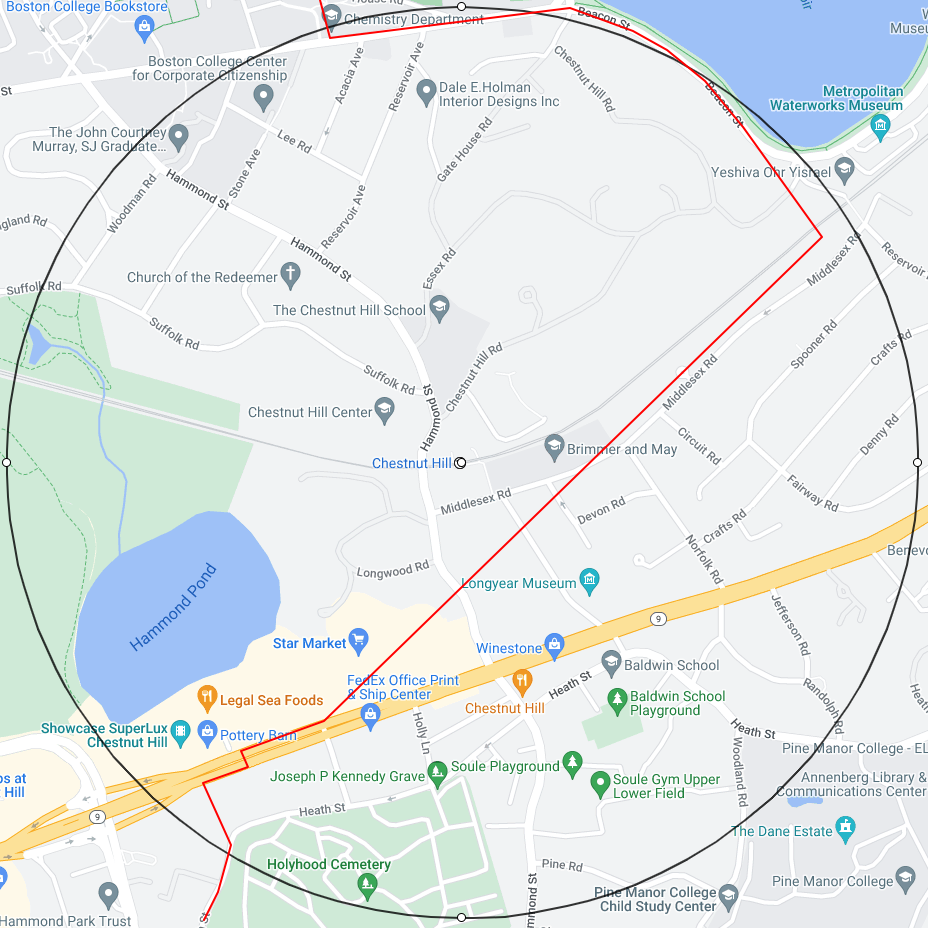
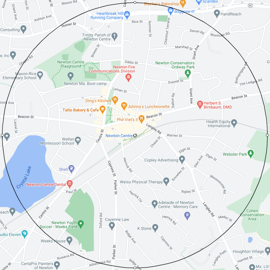
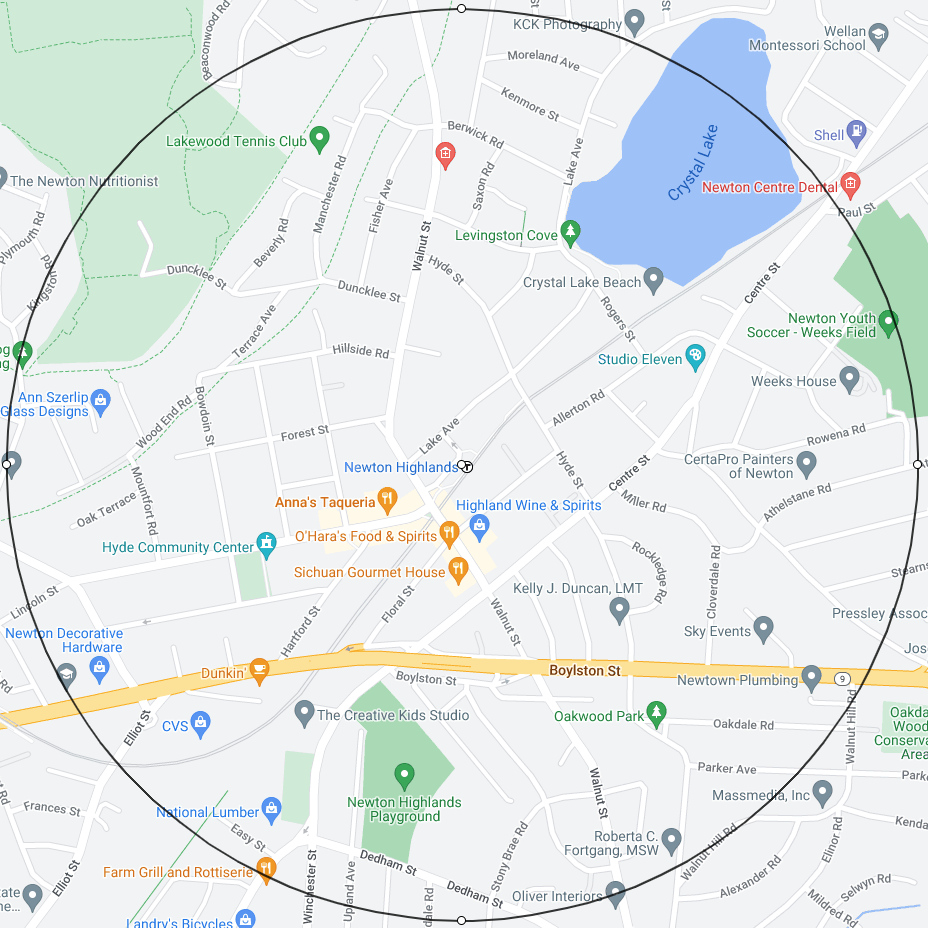
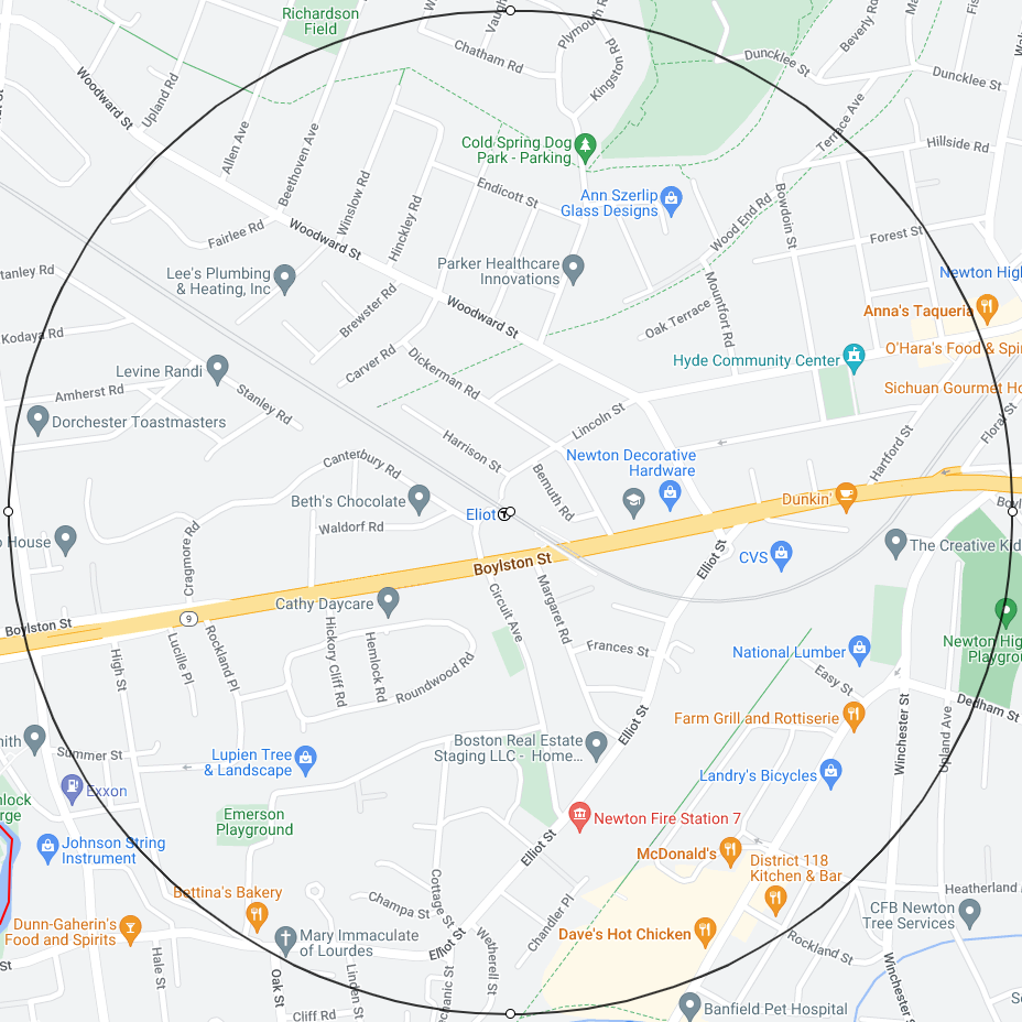
Newton has 8 rapid transit stations: Boston College, Chestnut Hill, Newton Centre, Newton Highlands, Eliot, Waban, Woodland, Riverside.
Newton has 3 commuter rail stations: Newtonville, West Newton, Auburndale.
A “bus station” in the MBTA Compliance definition requires substantial physical infrastructure and no bus stop in Newton qualifies.
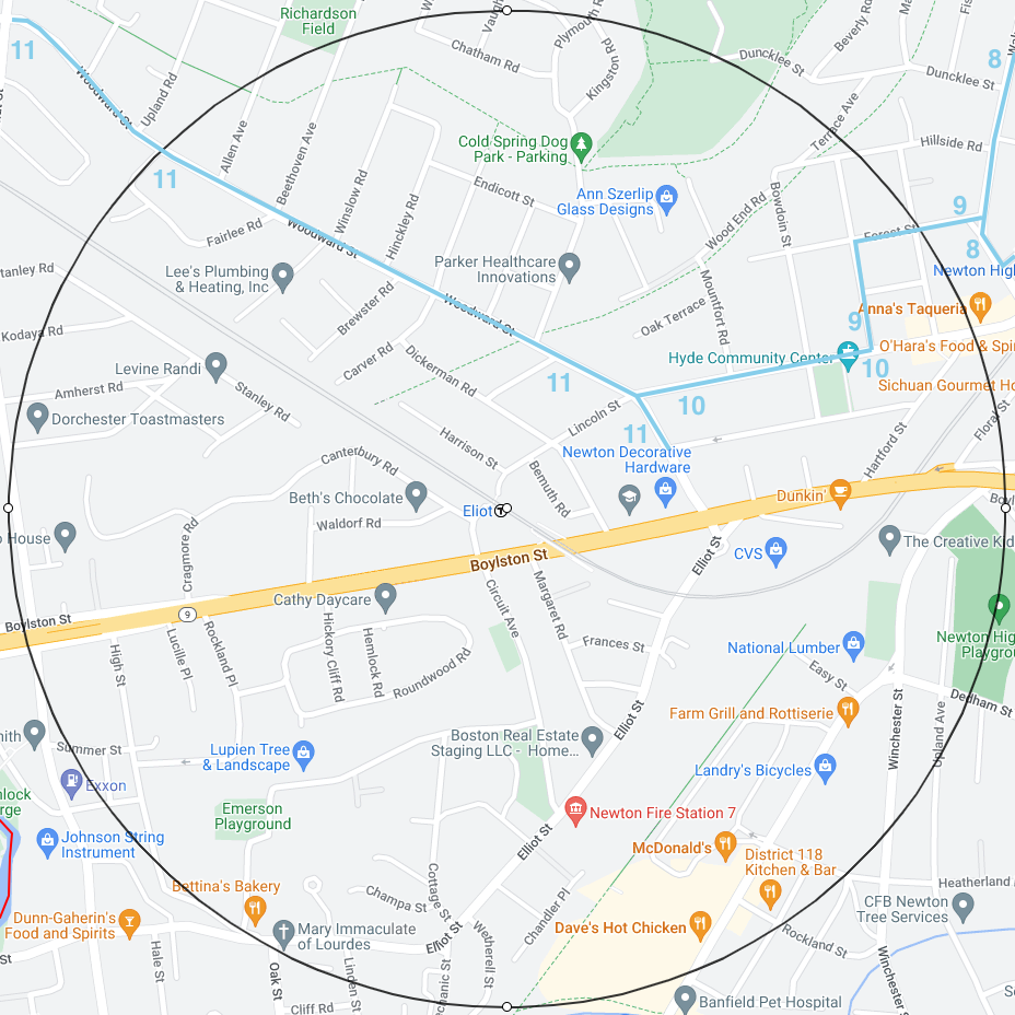
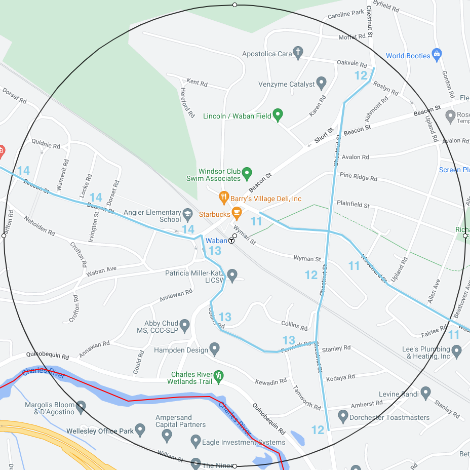
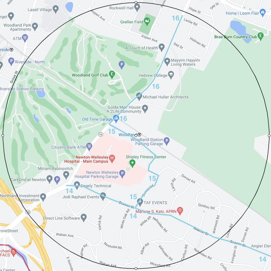
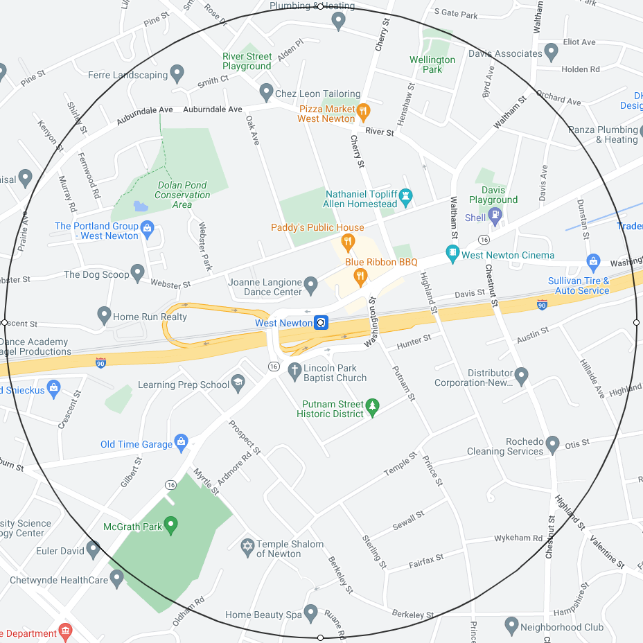
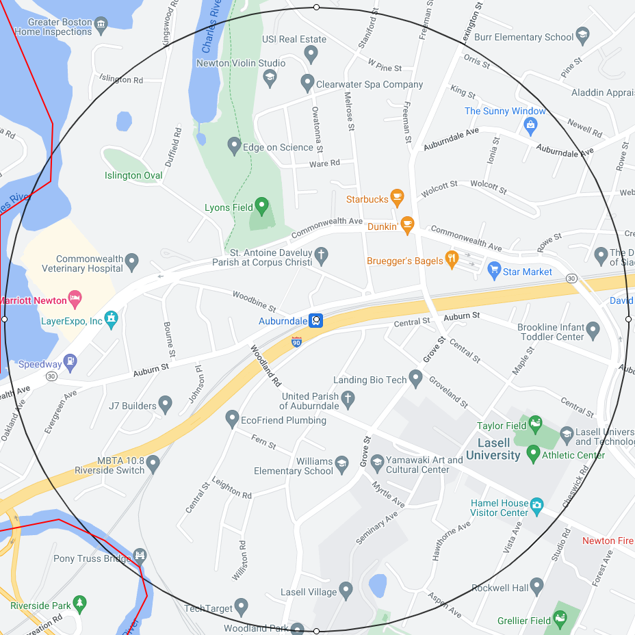
To see the half mile circles at the 11 Newton transit stations, see the Appendix:
The MBTA Compliance rationale for focusing on half mile circles around transit stations is:
MBTA communities with subway stations, commuter rail stations and other transit stations benefit from having these assets located within their boundaries and should provide opportunity for multi-family housing development around these assets. MBTA communities with no transit stations within their boundaries benefit from proximity to transit stations in nearby communities.
When possible, multi-family zoning districts should be in areas that have safe, accessible, and convenient access to transit stations for pedestrians and bicyclists.
MBTA Compliance: Percentage of enabled housing that must be within half mile circles
The MBTA Compliance “ideal goal” is to have multi-family housing be within half-mile circles around transit stations:
Section 3A states that a compliant multi-family zoning district shall “be located not more than 0.5 miles from a commuter rail station, subway station, ferry terminal or bus station, if applicable.”
Recognizing that this ideal might not be attainable, the MBTA Compliance regulations created a table to determine what percentage of the zoning must be within half-mile circles around transit stations:
The percentage in the table applies to two quantities:
- the percentage of housing units that must be within half-mile circles around transit stations
- the percentage of zoned land area that must be within half-mile circles around transit stations
The 90% Rule for Newton: Since Newton has more than 800 acres of developable station area:
- 90% of housing units must be within half-mile circles around transit stations
- 90% of zoned land area must be within half-mile circles around transit stations
MBTA Compliance: Percentage of enabled housing that must be in one large contiguous district
There is one additional important rule:
The 50% Rule.
As stated in the MBTA Compliance document:
In all cases, at least half of the multi-family zoning district land areas must comprise contiguous lots of land.
This rule has somewhat obscure wording but the interpretation is: 50% of the total district needs to be in one contiguous district.
In other words, there must be one large contiguous district of zoned area that is at least 50% of all zoned area.
For Newton, due to the 90% rule, the large contiguous district with at least 50% of all zoned area must fall into an overlapping chain of half mile circles around transit stations.
There is one final requirement: The zoned area must be at least 50 acres in total. This is easily satisfied by Newton due to the large number of housing units that must be enabled.
Discussion of Village Center Zoning Version 2 and MBTA Communities Zoning
Recap of my earlier Discussion of Village Center Zoning Version 1
In January 2023, I wrote an analysis of Version 1 of Village Center Zoning:
In this document, I examined:
- The stated purpose of the Village Center 1 (VC1) district:
Village Center 1 (VC1). The VC1 District facilitates small to medium scale multi-family buildings given its proximity to amenities, mixture of uses, and transit options found in Newton’s village centers. This district acts as a transition between the mixed-use cores of village centers and the surrounding residential neighborhoods.
- The desire to permit mixed-use in VC1 despite the stated VC1 purpose being to promote small to medium scale multi-family buildings.
- Area and Transit Studies
-
- The area occupied by the 12 village center districts as compared to one another.
- The area occupied by the 12 village center districts as compared to the total area of Newton {2.72%}.
- The disparate public transit offered in the 12 village center districts.
- Residential Density Issues
-
- The very high residential density enabled in the VC1 districts {40-50 units per acre}.
- The fact that a significant number of existing residential buildings {apartments and homes} have been zoned into VC2 or VC3.
- The absence of legal language that would incentivize adaptive reuse as opposed to tear downs.
Concerning residential density issues, I concluded:
In my opinion, the intense increase in residential density allowed by the current version of the zoning ordinance and the ability of developers to do what they wish “by right’ is a financial and legal combination of forces that incentivizes tear downs. To state it bluntly:
Residential buildings in the VC zones will be designated for demolition.
In the Suggestions section of the document, I opened with the following recommendation:
I believe that the cleanest solution to the problems of the current zoning starts with replacing VC1 by an MR type zone that is explicitly residential. Let me call the zone MRX.
The huge advantage of this solution is that MRX may be used all over Newton and be introduced to well chosen areas on a gradual basis. This can lead to a graceful increase in density over time.
Issues with Village Center Zoning Version 2 and MBTA Communities Zoning
In an initial examination of Version 2 of Village Center Zoning, I was pleased to see that the Planning Dept introduced a new more moderate zone, MRT or “Multi-Residence Transit” that reflects my suggestion of an MRX residential zone and that appears to solve the problems of the original base zone, VC1.
However, on closer inspection, the situation with Version 2 is not so rosy. I will list some of the issues immediately but it will take much of this document to discuss all of the issues thoroughly.
- The Version 2 zoning ordinance is written in such a way that any rule for the VCOD overlay districts will automatically override a corresponding general rule designed for Newton as a whole. The wording is so general that it will apply not only to what provisions are in the ordinance now but also to any provisions that are added to the ordinance in the future. This is a blank check to allow the VCOD zones to be zones that permit things that are not permitted in the rest of the city.
- I had assumed when I made my suggestions that the new zone MRT would replace the earlier zone VC1. This is not case. The zoning ordinance now has 4 zones: MRT, VC1, VC2, VC3.
- The zoning ordinance envisions the possibility of multiple buildings on a lot in VCOD zones. In VC1, VC2, and VC3, multiple buildings may be built by right. In MRT, multiple buildings will require a special permit. However, the only criterion for the special permit is a site plan review. No details are given for what conditions must be met for a YES or NO decision on the special permit during the site plan review. Given this vagueness, one must assume that the answer on the special permit for MRT will normally be YES.
- If there are multiple buildings on a lot, the minimum spacing between buildings is extremely small: 15 feet in MRT and VC1 and 25 feet in VC2 and VC3.
- A fundamental new rule introduced in Version 2 is that there will be no minimum parking requirements for buildings in the VCOD zones. In the discussion by the Planning Dept at the ZAP meeting of April 24, it was clear that the reason for the elimination of parking requirements was to enable more housing units to be built on the substantial amount of land that would otherwise be taken up by “grade level parking”. It was noted by Planning that the “MBTA Compliance tool assumes grade level parking, which reduces the building area left for units”. It was also noted that “a few Councilors expressed hesitancy with the removal of parking minimums entirely”. There was no discussion of how the families living in more than 10000 units of VCOD housing will be able to move about Newton with no cars and with quite limited intra-city public transit.
- The combination of:
-
- The ability to build multiple buildings on a lot
- The extremely small spacing between such buildings
- The elimination of parking requirements
- The absence of significant open space requirements
- will grant permission to create very high density developments across all VCOD areas. Even MRT is not spared. Although the ZAP report of April 24 uses the phrase “low density MRT district”, in reality an MRT lot under the Version 2 rules can achieve a density close to that of a VC1 lot under the Version 1 rules.
- Another fundamental new rule introduced in Version 2 is that if a developer agrees to certain higher percentages of affordable housing in a VC2 or VC3 building then they will be granted additional building height and additional building footprint.
- The details are:
-
- Additional building height rules:
-
- In VC2 or VC3, a developer will be granted 1 additional story in height if they agree to increase the affordable housing percentage from 17.5% to 25%. However, this bonus may not be used within 50 feet of a lot line abutting an MRT or residential district.
- In VC3, a developer will be granted 2 additional stories in height if they agree to increase the affordable housing percentage from 17.5% to 30%. However, this bonus may not be used by VC3 lots abutting a VC1, MRT, or residential district.
- Additional building footprint rules:
-
- In VC2 or VC3, if a height bonus is applicable then the maximum building footprint is increased by 2500 SF.
- In my opinion, the concept of a “height bonus” is utterly unacceptable. I am a Newton Corner resident. We in Newton Corner know first hand the destructive impact of extremely tall buildings in the midst of the village center. The Newton Corner Neighborhood Association requested in conversations with Planning Dept that there be no additional VC3 in Newton. It was with great reluctance that we agreed to some VC3 locations but this agreement was based on the height maximum of 4.5 stories in VC3. With the the concept of a “height bonus”, we feel that our past negotiations and agreements have been undermined. I have tracked every document posted in the Community Testimonials and I see that other village centers have expressed similar concerns with building height. The only testamonials that have supported the concept of a “height bonus” are housing advocacy groups that want affordable housing at all costs. I have seen not a single sentence in these support documents that acknowledges that additional building height might be considered quite detrimental to the community.
- The Planning Dept has made the following summary of the MBTA Compliance portion of VCOD under Version 2:
-
- 10000 units of housing
- 35 housing units per acre
- 288 acres
- 100% of the housing units fall within one half mile of a transit center
- the large contiguous zone occupies 69% of the area of the MBTA zoned district
- The MBTA Compliance mandate is:
-
- 8830 units of housing
- 15 housing units per acre minimum
- 90% of the housing units must fall within one half mile of a transit center
- 50% of the housing units must fall within one contiguous zone
- there must be one large contiguous district that occupies at least 50% of the area of the MBTA zoned district
- What immediately stands out is that the housing unit density proposed by the Planning Dept [35 units per acre] is far in excess of that mandated [15 units per acre]. This intense housing is a choice being made by the Planning Dept. This choice is not a mandate.
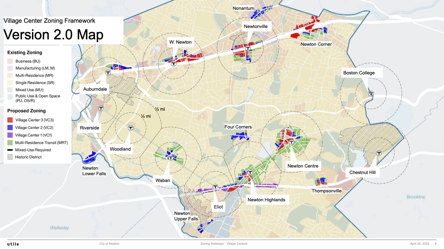
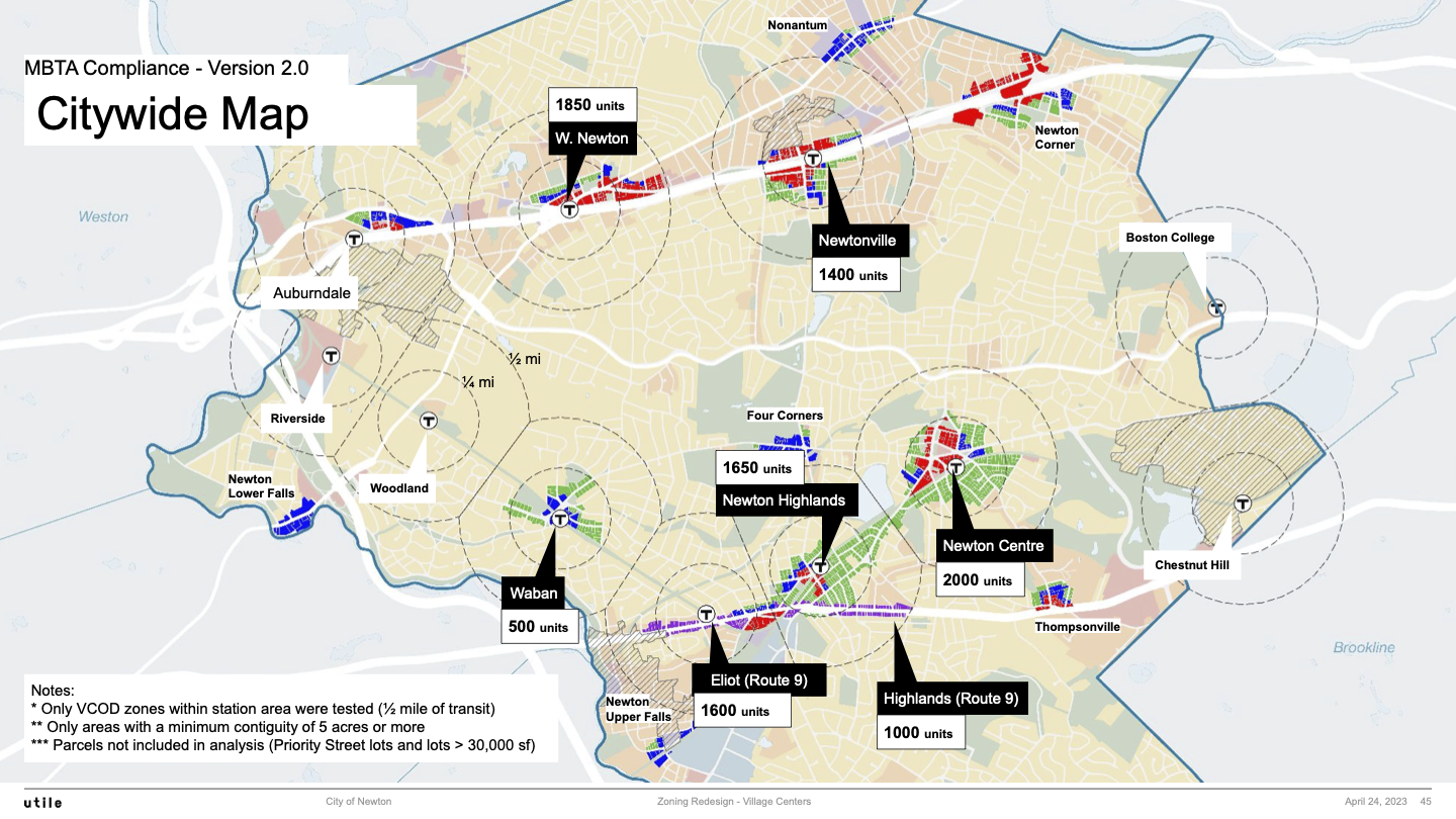
- It is instructive to look at the two Planning Dept citywide maps to learn some of what is going on:
- Citywide Zoning Map for 2.0
- Citywide MBTA Compliance Zoning Map for 2.0
- In citywide zoning map, you can see a new Route 9 District that is indicated by the colors purple, blue, and red for VC1, VC2, and VC3. You will also note a small touch of green for MRT on a few lots. Visually examining the area of this Route 9 District, you can see that it is tiny in comparison to the rest of VCOD zoned areas in Newton.
- In the citywide MBTA Compliance zoning map, you can see is that 2600 of the 10000 housing units needed for MBTA Compliance have been placed in the new Route 9 District. I will list the number of housing units in the 6 areas designated for MBTA Compliance together with the percentages that these numbers represent:
- 2600 housing units [26.0%]: Route 9 District
- 2000 housing units [20.0%]: Newton Centre
- 1850 housing units [18.5%]: West Newton
- 1650 housing units [16.5%]: Newton Highlands
- 1400 housing units [14.0%]: Newtonville
- 500 housing units [ 5.0%]: Waban
- The largest number of housing units is concentrated in the tiny Route 9 District.
- I plan to discuss the Route 9 District in depth below.
It is interesting to look at the housing unit data above in a different manner, namely, by grouping districts into the the large contiguous district and all the rest.
The large contiguous district
2600 housing units [26.0%]: Route 9 District
2000 housing units [20.0%]: Newton Centre
1650 housing units [16.5%]: Newton Highlands
Percentage total: 62.5%
All the rest
1850 housing units [18.5%]: West Newton
1400 housing units [14.0%]: Newtonville
500 housing units [ 5.0%]: Waban
Percentage total: 37.5%
This is interesting because the large contiguous district occupies 69% of the MBTA zoned area but it only accounts for 62.5% of the housing units. This is worth pondering.
It should be noted that 7 of the village centers in the VCOD zoning are not included in the MBTA Compliance computation: Auburndale, Four Corners, Newton Corner, Newton Lower Falls, Newton Upper Falls, Nonantum, and Thompsonville. There are of course additional housing units enabled in these village centers. That is why there will be substantially more than 10000 housing units enabled in VCOD when all VCOD districts are accounted for.
The Planning Dept should list in a separate table the enabled housing units in the 7 village centers not in the MBTA Compliance computation so that Newton citizens can learn the total of VCOD enabled housing in the entire city.
What zoning policies are being followed in the VCOD Version 2.0/2.1 proposal?
Here is what I deduce about the zoning policies from the evidence of the zoning code being presented:
- Zone as little land area in Newton as possible.
- Set building footprint limits but then make it as easy as possible to have multiple buildings on a lot.
- Further increase the opportunity for building density on a lot by having no minimum parking requirements.
- Override the original Version 1.0 building height limits in VC2 and VC3 by the invention of the affordable housing height bonus. [Note: any height bonus also comes with an increase in the building footprint limits].
- Obtain 26% of the 10000 housing units submitted for MBTA Compliance by the invention of the tiny Route 9 District and then append this district to the contiguous path from Newton Centre to Newton Highlands in order to also meet the requirements for a contiguous MBTA zoned area that is at least 50% of the total MBTA zoned area. Ignore the possibility of extending the contiguous path further into Newton along Woodward St and beyond [and therefore avoid the use of a Route 9 District altogether].
- Use only footprint and height as form based constraints. Do not get more specific by promoting the use of specific building forms in MRT and in the VC districts.
If the zoning policies described above are not the policies of the Zoning and Planning Committee and the Planning Dept then I ask:
- What exactly are the zoning policies of the Zoning and Planning Committee and the Planning Dept?
- How do these zoning policies lead to the VCOD Version 2.0/2.1 zoning that is being proposal?
I view the results embodied in VCOD Version 2 proposal as intense dense zoning. This is especially the case in the Route 9 District.
Since there is no protection against multiple buildings on an MRT lot and there are no minimum parking requirements, there may be substantial density in MRT.
In VC2 and VC3, the VCOD Version 2 rules:
- permit larger building footprint
- permit more horizontal density with multiple buildings allowed by right and with no minimum parking requirements
- permit more vertical density with initial heights of 3.5 and 4.5 stories and with height bonus options of 1 or 2 stories
This means that VC2 and VC3 may be extremely dense.
It is my goal to propose instead a vision for more mellow zoning in Newton.
However, I wish to first discuss the Route 9 District to hopefully put that idea to rest.
Recommendation: Eliminate the Route 9 District
We have already shown above the Planning Dept citywide MBTA Compliance zoning map:
Citywide MBTA Compliance Zoning Map for 2.0
What you can see is that 2600 of the 10000 housing units needed for MBTA Compliance have been placed in a new Route 9 District which is a narrow strip that starts just west of Clark St and continues west to Cragmore Rd [which is a short distance from Chestnut St].
The distance along Route 9 of this Route 9 District is 1.35 miles.
I strongly suggest that you click on the next two maps so you may see them in separate tabs and then click on either map to zoom in for details.
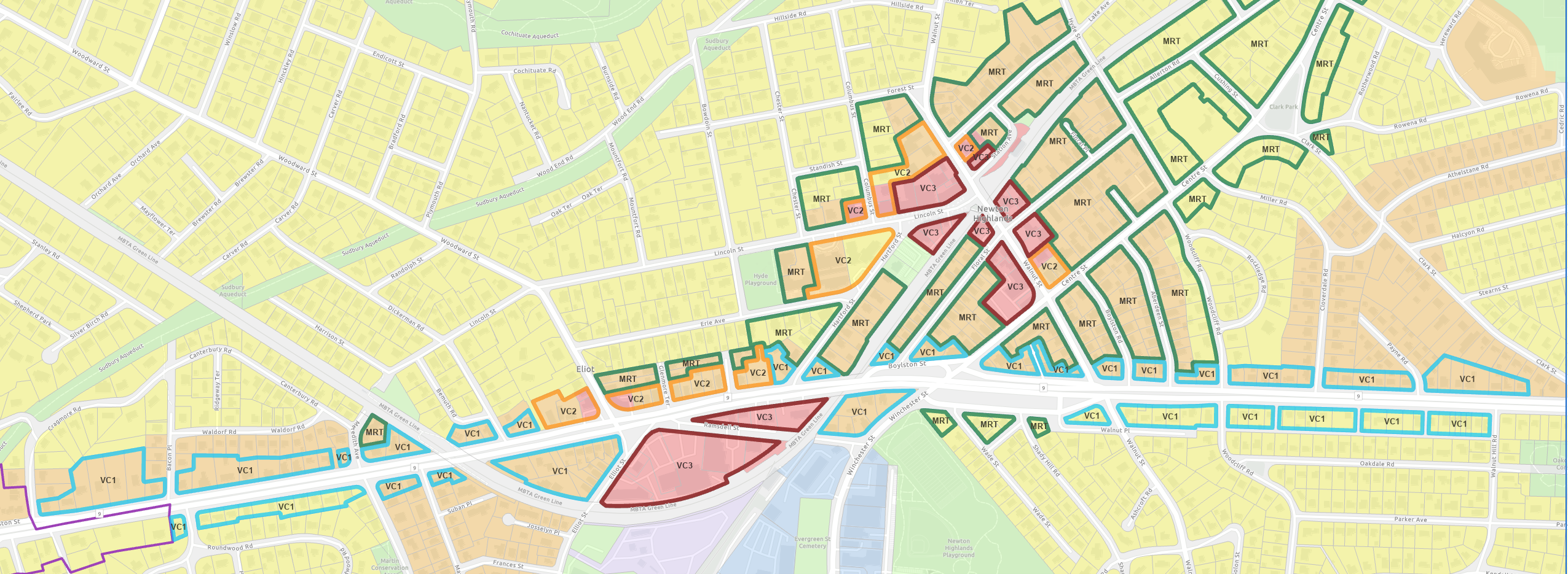
Below is the Route 9 District and a part of Newton Highlands via the Interactive Zoning map app:
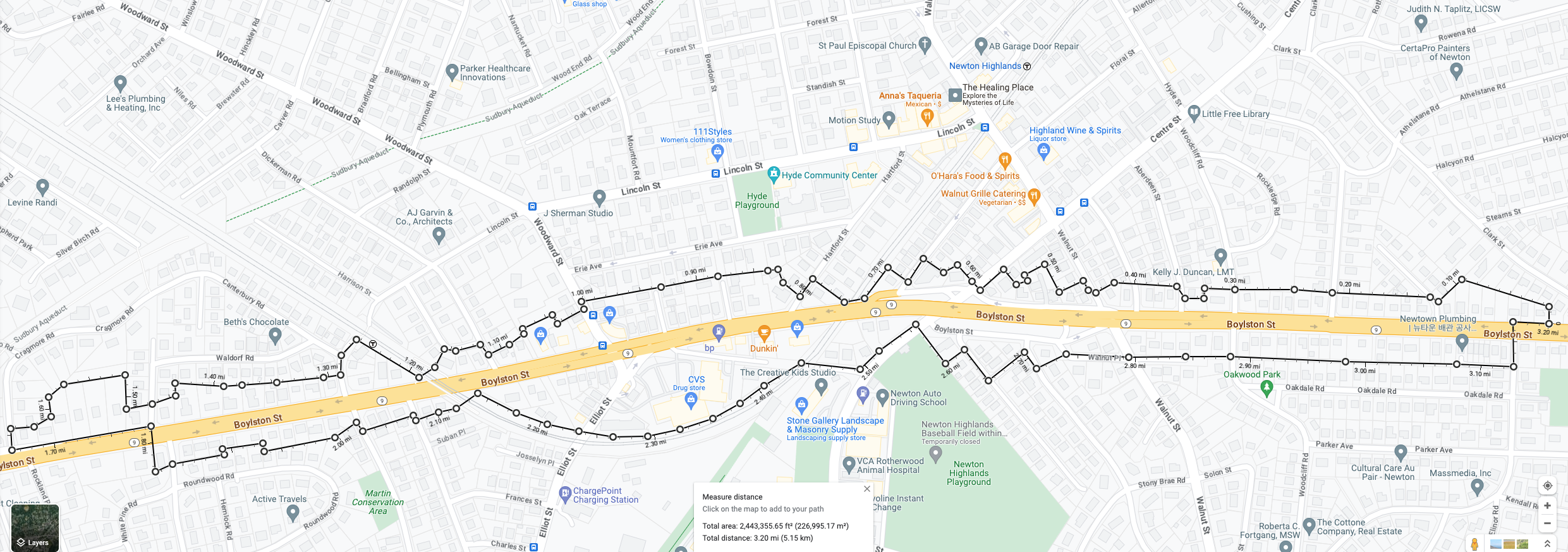
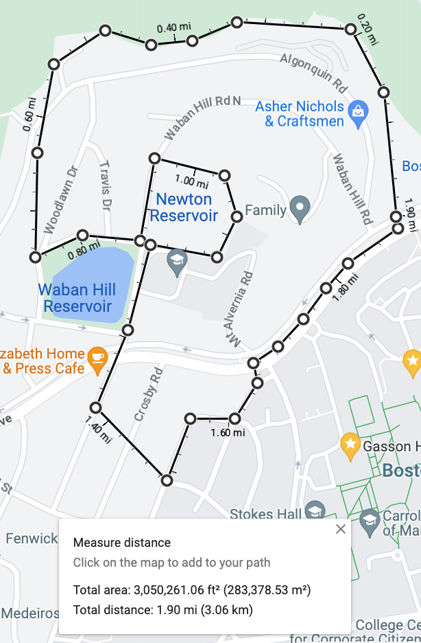
Below is a Google map of the Route 9 District that shows its boundary and its area:
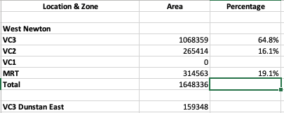
The Route 9 District area is 2443356 SF = 56 acres.
Normally the width of the Route 9 District [on either side of the highway] is one or two house lots from Route 9. Therefore, normally, the district width is quite narrow. The widest point of the Route 9 District is at the intersection of Route 9 with Woodward St to the north and Elliot St to the south.
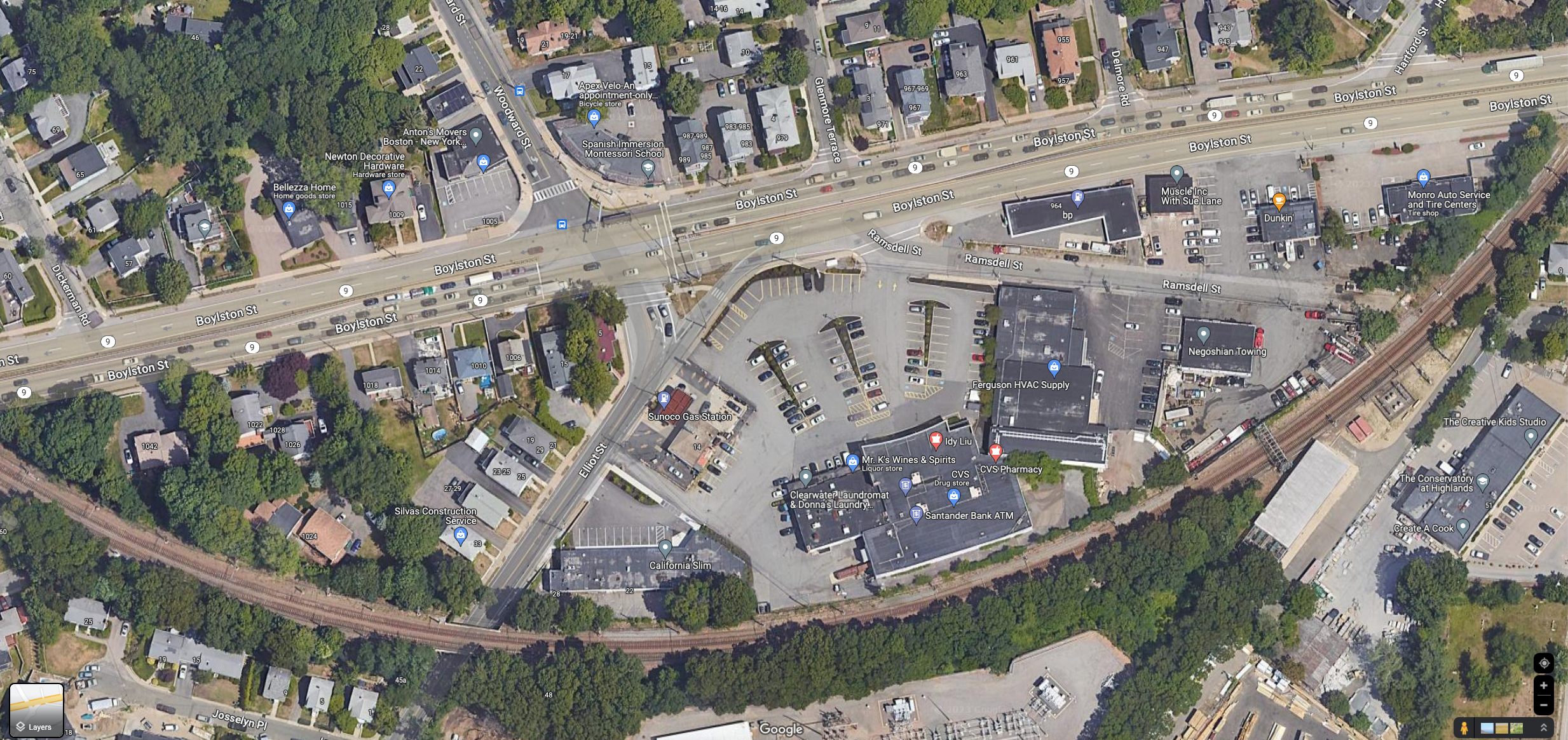
Route 9 at Woodward St & Elliot St
At this widest point, the land “bulge” between Route 9 and the Green line tracks to the south is included in the Route 9 District. The total width of the district at this point is 684 FT = 0.13 miles.
Note that Route 9 is 70-80 FT in width. Route 9 is not part of the buildable area but must be included in MBTA Compliance area calculations.
Let us now compare 3 areas:
- The entire MBTA zoned area in Newton
-
- Housing Units: 10000
- Acres: 288 acres
- Housing Units per Acre: 35 units per acre
- The MBTA zoned area along Route 9
-
- Housing Units: 2600
- Acres: 56 acres
- Housing Units per Acre: 46 units per acre
- Percentage of MBTA zoned area: 56/288 = 19%
- The MBTA zoned area in Newton other than Route 9
-
- Housing Units: 7400
- Acres: 288 - 56 = 232 acres
- Housing Units per Acre: 32 units per acre
- Percentage of MBTA zoned area: 232/288 = 81%
Therefore, the Route 9 District which occupies 19% of the MBTA zoned area is responsibe for 26% of the MBTA zoned housing units and has a housing density [46] which is 44% more than the housing density average for the rest of the MBTA zoned area in Newton [32].
Before VCOD Version 2.0, no one in Newton spoke of the intersection of Route 9 at Woodward St & Elliot St as a village center. Now the Route 9 District has been invented and then designated to bear the burden of 26% of the housing units planned for MBTA Compliance. This action unfortunately fits a historical Newton zoning pattern: If you wish to do something drastic, find a less favored neighborhood, that is, a less affluent neighborhood, and then do the zoning deed there. It is quite telling that while VC1 was entirely replaced by MRT in the rest of Newton, in the Route 9 District there is only a sprinklng of MRT with the lion’s share of the zoning being VC1, VC2, and VC3. It is clear that this was done to maximize the the projected number of housing units for MBTA purposes.
It is also clear that the actual creation of 2600 housing units in the Route 9 District would require the complete demolition of the buildings currently in the area.
I strongly recommend that the City Council insist that the concept of a Route 9 District be entirely taken off the table. The Route 9 District is the zoning equivalent of a gerrymander. Who can say that a district
- that is 1.35 miles long, is usually quite narrow, and is 0.13 miles wide at its widest
- that is bisected by a major highway (Route 9)
- that has exactly 5 places where a pedestrian may cross this highway
can in any meaningful sense be considered a neighborhood for zoning purposes.
Eliminate the Route 9 District.
Recommendation: Eliminate VC1 as a Zoning Category
If you have accepted the argument above that the Route 9 District should be entirely eliminated then it follows that the VC1 zone should be eliminated as well, since the usage of VC1 is restricted to the Route 9 District.
Discussion of Excerpts from the VCOD Version 2.1 Zoning Code
As background to the discussion below, I excerpt here some introductory sections of the VCOD Version 2.1 zoning document.
from 2.2. District Purpose
The Village Center Overlay District (VCOD) has been divided into four (4) distinct tiers of districts:
A. Multi Residence Transit (MRT). The MRT District facilitates new, small-scale, multi-family buildings similar in size to the surrounding residential neighborhoods and the preservation of existing homes through conversion to multiple units. This district acts as a transition between the mixed-use cores of village centers and surrounding residential neighborhoods.
B. Village Center 1 (VC1). The VC1 District facilitates small- to medium-scale multi- family buildings given its location along major corridors and proximity to amenities, mixture of uses, and transit options found in Newton’s village centers. This district acts to link certain village centers and allows for neighborhood serving retail along key corridors and intersections.
C. Village Center 2 (VC2). The VC2 District facilitates mixed-use and residential development of moderate scale. This district serves as the core of some village centers and as a transition district for other village centers. Buildings are typically set close to the sidewalk to create a defined street wall that supports pedestrian activity and a sense of place. Ground story active uses address the needs of residents and employees in the immediate neighborhood as well as the larger Newton Community.
D. Village Center 3 (VC3). The VC3 District facilitates mixed-use development of moderate- and large-scale. This district serves as the core commercial zone of certain village centers, particularly those with access to mass transit. Buildings are typically set close to the sidewalk to create a defined street wall that supports pedestrian activity and a sense of place. Ground story active uses address the needs of residents and employees in the immediate neighborhood, the larger Newton Community, and regional visitors.
from 2.3. Definitions
In addition to the definitions found in Article 8 Definition, the following definitions apply.
Many technical definitions are skipped. I focus on one definition: “Residential District”.
W. Residential District. Residential districts include lots located in the Single Residence (SR), Multi Residence (MR), and Multi Residence Transit (MRT) zoning districts.
Concerning MRT
I wish to point out that the following sentence in the District Purpose of MRT is quite problematic:
This district acts as a transition between the mixed-use cores of village centers and the surrounding residential neighborhoods.
This sentence was lifted verbatim from the District purpose of VC1 in Version 1.0. In the context of Version 2.0/2.1 and MRT, this sentence does not make sense. Why?
- MRT is a residential district. MRT is not a transition district to a residential district.
- In the nature of an overlay district, MRT buildings will mix in with legacy buildings as development happens over time. There will be no clear demarcation line between MRT lots and the lots in the zone that it overlays. There is no transition.
- In the proposed zoning, MRT overlays SR2, SR3, MR1, MR2, and MR3 zoned lots. To confirm this, you may wish to examine the comparison maps below.
- MRT buildings will therefore mix in with all of the zoning types: SR2, SR3, MR1, MR2, and MR3.
The Planning Dept has set a fundamental precedent with its VCOD Version 2.0/2.1 zoning maps:
The MRT overlay district may insert multi-family buildings into existing single residence (SR) districts.
This precedent is not a mistake on the part of the Planning Dept.
The requirements of the MBTA Communities Law for one large contiguous district area within half mile circles of transit stations combined with the existing zoning in Newton that strongly emphasizes single residence (SR) districts forces the insertion of of multi-family buildings into existing single residence (SR) districts.
It is the intention of the MBTA Communities Law to make this happen, not just in Newton but across the state. It is considered the only way to enable significant housing opportunities in Massachusetts.
See the section:
Once we understand that multi-family buildings will be inserted into single residence (SR) districts, I suggest that it is incumbant on the city to make the multi-family buildings fit in as seemlessly as possible. I discuss this in the section:
Concerning VC1
I have discussed above the reasons to eliminate the Route 9 District and, as a consequence, to eliminate VC1 which is used only in the Route 9 District. Therefore, VC1 should be dropped. There should remain only three districts: MRT, VC2, and VC3. To avoid total confusion in the community, VC2 and VC3 should not be renumbered.
Concerning VC2 and VC3
There is also a problematic sentence in the District Purpose of VC2 and VC3:
Buildings are typically set close to the sidewalk to create a defined street wall that supports pedestrian activity and a sense of place.
Why on earth do pedestrians in village centers need a street wall so that we will have a sense of place?
I think that, as pedestrians, we will know when we are in village centers and we do not need a canyon like street wall to tell us this.
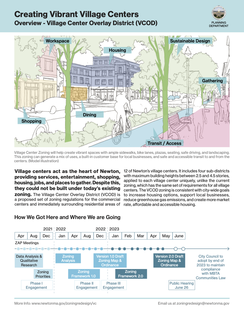
The Planning Dept has used the following image to sell the concept of Vibrant Village Centers to the Newton community, both in the past and just before the public hearing of June 26:
This image shows an inset public plaza forming a courtyard with mixed use businesses wrapping around the edges of the plaza. The public plaza seems to be a really nice feature to have in a village center.
However, the concept of a street wall and the VCOD Version 2.1 zoning code that supports this idea effectively prohibits public plazas.
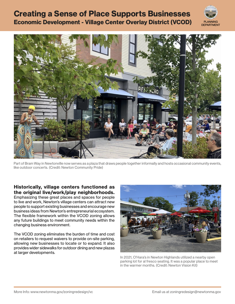
In the same Zoning Redesign Info Sheet from which the above image was taken, there is a page with the title Creating a Sense of Place Supports Businesses:
The Sense of Place is provided by the Bram Way public plaza which is just the kind of space that the VCOD Version 2.1 zoning code would prohibit.
The solution to this problem is:
Throw out the idea of a street wall and change the VCOD Version 2.1 zoning code to be more flexible and thereby encourage vibrant public spaces such as plazas and other variations of form.
Another issue. The final sentences in the District Purpose for VC2 and VC3 are almost the same but not quite:
VC2:
Ground story active uses address the needs of residents and employees in the immediate neighborhood as well as the larger Newton Community.
VC3:
Ground story active uses address the needs of residents and employees in the immediate neighborhood, the larger Newton Community, and regional visitors.
Why aren’t these two statements identical? VC2 and VC3 are essentially the same except that VC3 is taller. Regional visitors are just as likely to go to VC2 as to VC3.
A final issue. The page Creating Vibrant Village Centers shown above [which is the first page of the 13 page Zoning Redesign Info Sheet] has the following statement about VCOD zoning in fine print. I have separated the statement into its three sentences.
The Village Center Overlay District (VCOD) is a proposed set of zoning regulations for the commercial centers and immediately surrounding residential areas of 12 of Newton’s village centers.
It includes four sub-districts with maximum building heights between 2.5 and 4.5 stories, applied to each village center uniquely, unlike the current zoning, which has the same set of requirements for all village centers.
The VCOD zoning is consistent with city-wide goals to increase housing options, support local businesses, reduce greenhouse gas emissions, and create more market rate, affordable and accessible housing.
The problem with this is that it is no longer true that:
The maximum building heights are between 2.5 and 4.5 stories.
Now, due to the affordable housing bonus:
The maximum building heights may be as much as 6.5 stories.
The documentation in the Zoning Redesign Info Sheet seems to want to obscure this maximum building height increase as much as possible.
On page 3, Expanding Housing Choices for All, all visual examples show no more than 4.5 stories in height. The main prose does not discuss the height bonus. Then, there is an example with a table, VCOD Affordability Requirements. This table has asterisks that lead to footnotes printed in a smaller light gray font. These footnotes finally mention the height bonus rules.
On pages 5 and 6, there are Dimensional Standards for VC3 and VC2 respectively. The maximum height of VC3 is given as 4.5 stories and the maximum height of VC2 is given as 3.5 stories. There is no mention of a height bonus.
I think the situation presented in the Zoning Redesign Info Sheet document shows that the Planning Dept wants to change the maximum height rules but it does not wish to call attention to this in a way that will be absolutely clear to the general public.
The comparison maps below are referenced above in the discussion of MRT.
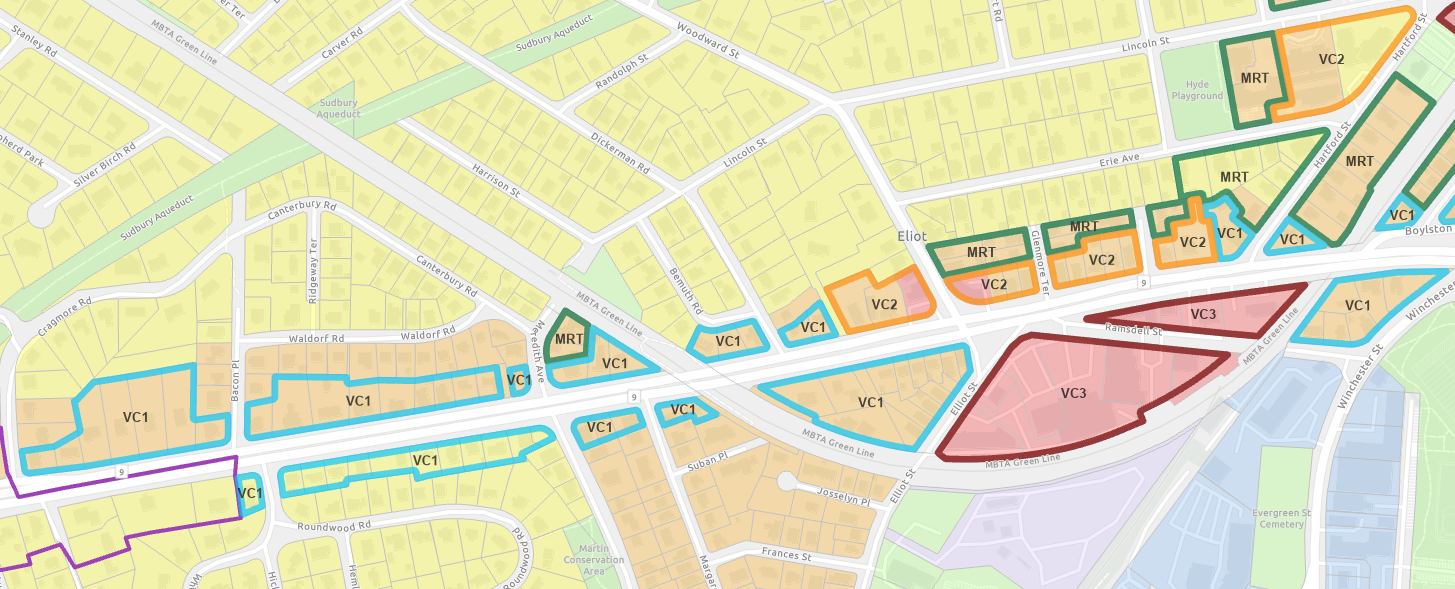
Comparison Maps: Current Zoning vs VCOD 2.0 Zoning near Newton Centre and Newton Highlands
You may click on either map to see an enlarged map in a separate tab.
Current Zoning near Newton Centre and Newton Highlands
VCOD 2.0 Zoning near Newton Centre and Newton Highlands
Mellow Zoning for MRT
In the Introduction, we explained the following rule:
MRT zoning may be an overlay district on top of the following current zones:
- Single Residence 2 (SR2)
- Single Residence 3 (SR3)
- Multi Residence 1 (MR1)
- Multi Residence 2 (MR2)
- Multi Residence 3 (MR3)
The precedent for the use of MRT as an overlay over all five of these zones is set by the Planning Dept in the VCOD Version 2 zoning between Newton Centre and Newton Highlands, especially, along Centre St between Paul St and Hyde St.
The fact that MRT may overlay Single Residence districts makes it especially important that whatever is built or renovated under MRT rules fits in smoothly with the context of the surrounding neighborhood. This is the reason that we will discuss the work of Daniel Parolek below.
To provide further context, let me make some extracts from a part of the discussion in the Introduction:
I propose that Newton use MRT to satisfy the MBTA Communites Law in one specific contiguous area, namely, in the contiguous residential areas of the 5 half mile circles at Newton Centre, Newton Highlands, Eliot, Waban, and Woodland. This MRT zoning may be called MBTA Communites Zoning.
The 5 Half Mile Circles
I assert:
It is absolutely imperative that the type of housing permitted by MRT be acceptable in Newton, especially, when the MRT overlay district is above a single residence district.
This where the ideas of Daniel Parolek about Missing Middle Housing are relevant:
Parolek’s ideas are also explained in greater depth in his book Missing Middle Housing.
Parolek and his company Opticos Design have worked for 20+ years on the concepts and the nitty gritty details of how to smoothly integrate multi-family housing into single family districts in as seamless a fashion as possible.
In this section on Mellow Zoning for MRT, I will show how to adapt the ideas of Daniel Parolek so that MRT zoning will lead to buildings that are indeed acceptable in Newton.
MRT will permit a multi-family building to be created on a existing lot either by construction of a new 3 or 4 unit building or by renovation of an existing residential building with possible additions. New construction should fit into its context in terms of quality of design and via dimensional constraints of footprint and height that guarantee that the building has appropriate scale. If renovation of an existing residential structure is chosen and if that renovation can enable more than 4 units then more units should be permitted. Further, renovation with additions may use a somewhat larger footprint than new construction.
I believe strongly that Newton should resist the temptation to put multiple buildings each having 3 or 4 units on a single MRT lot. I instead favor more generous dimensional constraints from the start so that what we desire to achieve in terms of housing units may be done with a single building with 3 or 4 units or, perhaps, with a pair of duplex buildings. The limit of a total of 3 or 4 units should apply to new construction. Note that if MRT is used to overlay a Single Residence (SR) district lot then the construction of multiple buildings each having 3 or 4 units on the lot would absolutely not fit into the context.
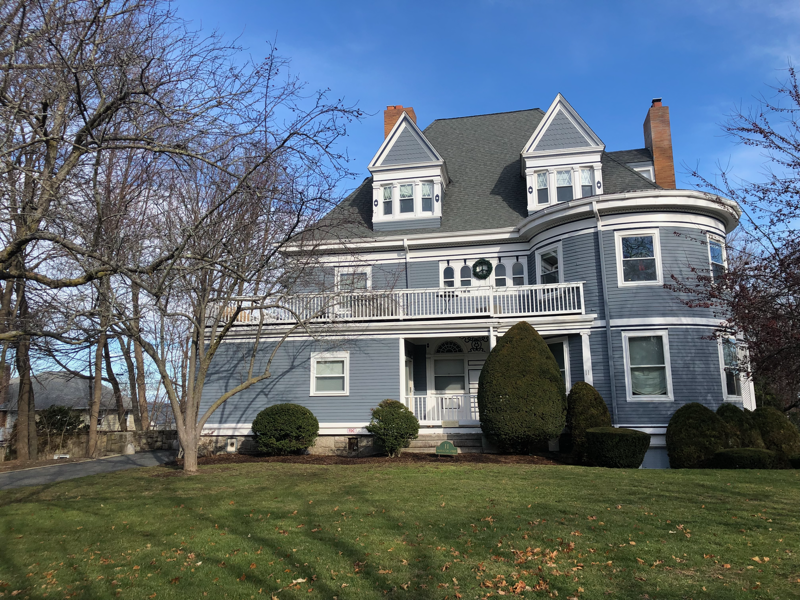
An example of housing renovation with more than 4 units was in fact shown by the Planning Dept in its presention of 2022-12-12 [page 4]. The property is 11 Washington St in Newton Corner which is a Victorian that has been converted to have 6 condo units. The building footprint is 4062 SF and the total floor space of the 6 units is 7896 SF.
This is a good example to keep in mind.
As I have indicated, my thinking about MRT and quality of design is strongly influenced by the work of Daniel Parolek and his firm Opticos Design [which was founded in the year 2000].
Parolek invented the concept of Missing Middle Housing and his key objective is to show how to fit multi-family buildings as seemlessly as possible in the midst of single-family dwellings.
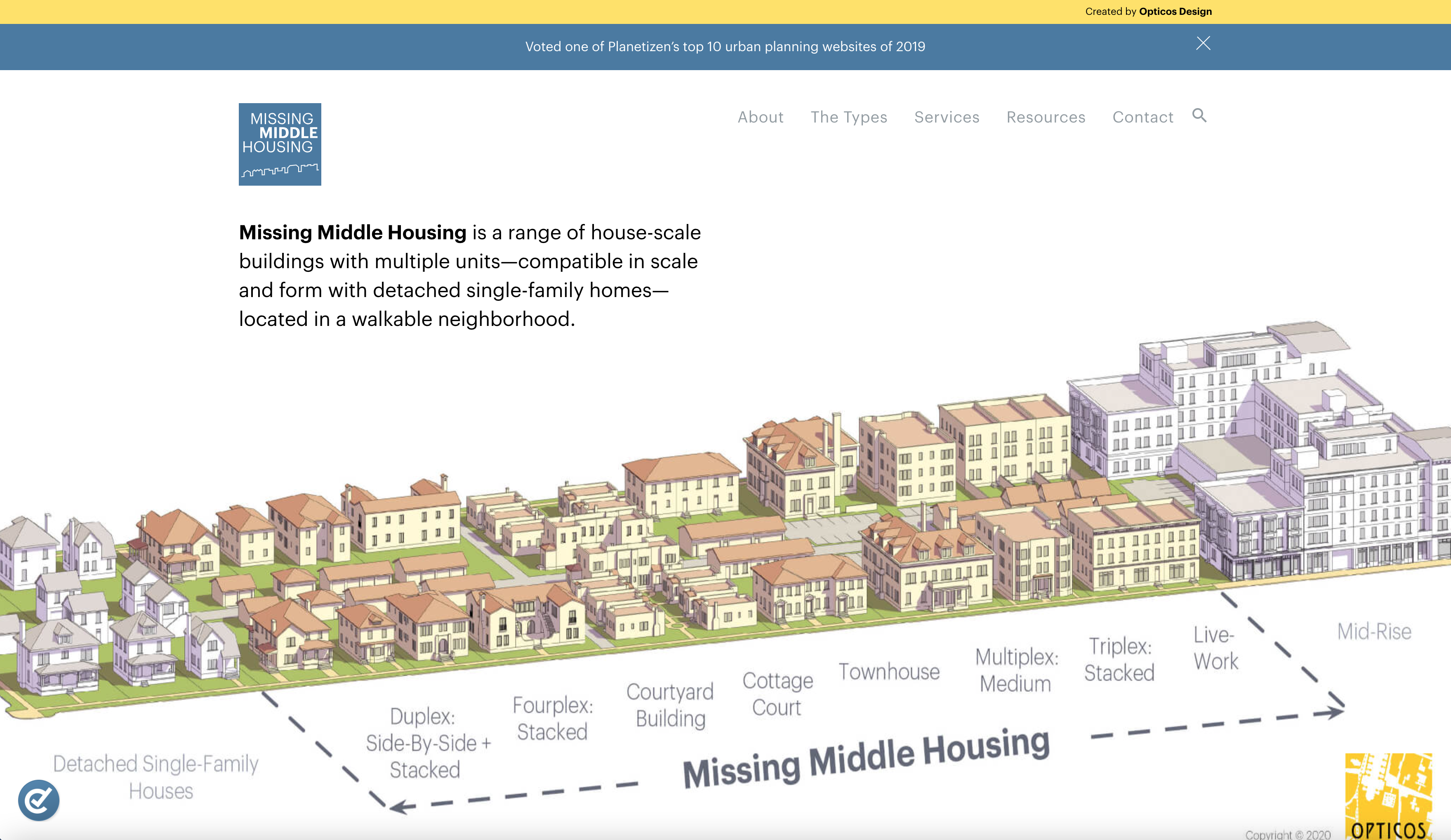
Below are the two key images on the Missing Middle Housing web site:
The Missing Middle Housing Diagram
Missing Middle Housing is a range of house-scale buildings with multiple units that are compatible in scale and form with detached single-family homes and that are located in a walkable neighborhood.
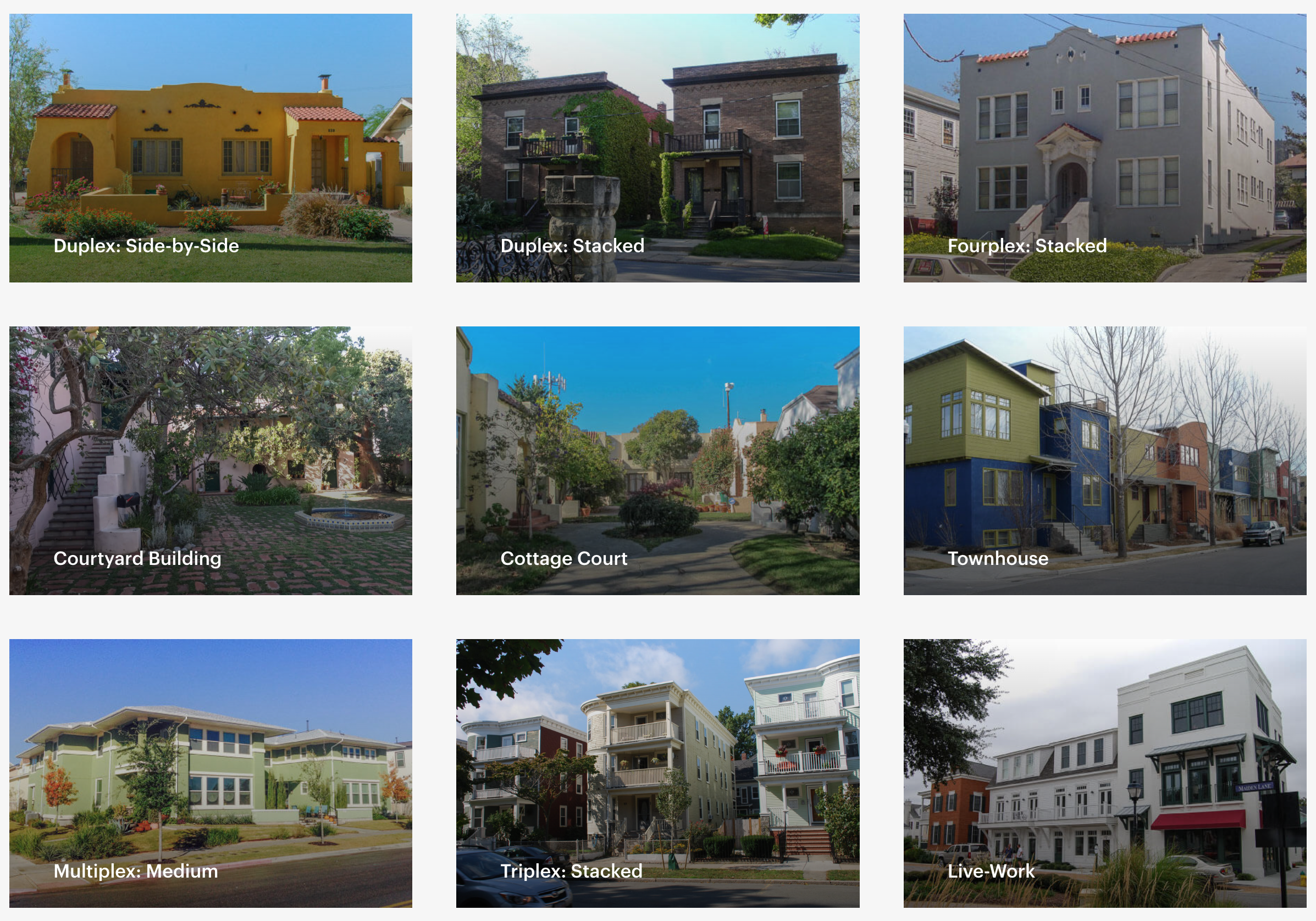
Photo examples of the Missing Middle Housing types
The Types: The Missing Middle Housing types provide diverse housing options, such as duplexes, fourplexes, cottage courts, and multiplexes. These house-scale buildings fit seamlessly into existing residential neighborhoods and support walkability, locally-serving retail, and public transportation options. They provide solutions along a spectrum of affordability to address the mismatch between the available U.S. housing stock and shifting demographics combined with the growing demand for walkability.
The Missing Middle options do not explicitly list one housing type that is quite relevant to Newton:
The Traditional 2.5 Story House with Pitched Roof:
- The most typical example has 3 units:
-
- two larger units on floors 1 and 2
- one smaller unit on floor 3
- Examples exist with 4 units
Presumably, the Traditional 2.5 Story House type is not listed by Parolek because it is not actually a “missing” multi-family housing type. This housing type occurs often.
Let me discuss the relevance of the Missing Middle options to Newton MRT zoning in the context of the MBTA Communities Law. One key MBTA Communities Law constraint is:
“Multi-family housing” means a building with 3 or more residential dwelling units or 2 or more buildings on the same lot with more than 1 residential dwelling unit in each building.
The MBTA Communities Law rules out the Cottage Court which consists of single unit buildings.
I think that the Newton zoning should explicity call attention to the following housing forms as options for MRT:
- The Traditional 2.5 Story House with Pitched Roof
- Fourplex houses
- A Pair of Stacked Duplex houses
- A Pair of Side-By-Side Duplex houses
-
- perhaps with one duplex in front and one duplex in back
- perhaps with the duplex buildings facing each other across an open courtyard
- A Courtyard Building, with 3 or 4 units
This list will make the MRT zoning somewhat more ”form based” and not just ”dimension based”.
Note: I think that the Pair of Side-By-Side Duplex houses option could be attractive to older citizens who wish to downsize into a small one story building with accessibility at grade level. The Pair of Side-By-Side Duplex houses option with the buildings facing each other accomplishes the same goal as a Cottage Court with 4 units.
Let me discuss the Missing Middle housing types that I do not think are appropriate for MRT. I have mixed feelings about the Town House and Triplex Stacked housing types because I think that Newton should stick to a 2.5 story maximum in MRT. Further, although Triplex Stacked is common in Boston, it is rare in Newton. I think that the Multiplex: Medium housing type is more suitable for buildings with more than 4 units. Finally, the Live-Work housing type is a special case of mixed-use and I would prefer that all mixed-use be in the VC districts.
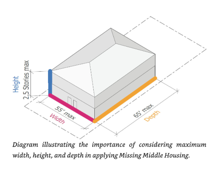
Parolek has recommendations on the footprint dimensions and the height maximum for core Missing Middle Housing types. These recommendations are based on 20+ years of experience integrating multi-family housing into single-family districts in communities across the country.
Missing Middle Core Dimensions: Width, Depth, Height
from the Missing Middle Housing book - page 19
The footprint maximum implied by these recommendations is 55 FT by 65 FT = 3575 SF. This footprint maximum is far greater than the 1500 SF footprint maximum for MRT stated in the current VCOD Version 2 zoning draft for MRT. I think that Newton would be wise to defer to the expertise of Dan Parolek in the matter of dimensional constraints.
In the context of Newton, lots may be many sizes and shapes. I therefore suggest that the MRT dimensional constraints should be formulated in a slightly more flexible manner:
In MRT, new construction should satisfy one of the following two dimensional constaints:
- Maximum width is 55 FT and maximum depth is 65 FT.
- Maximum footprint is 3600 SF.
This allows the city to indicate the preferred width by depth sizes but allows a developer to get a similar amount of footprint area if the lot does not permit the ideal rectangular shape.
Also, in MRT, new construction should have:
- Maximum height of 2.5 stories.
- Either 3 or 4 housing units.
I have said above that in MRT the option of renovations with additions should be allowed to have more units and a larger footprint. Here is the rule that I propose:
In MRT, the option of renovations with additions should satisfy:
- From 3 to 6 housing units.
- Maximum footprint is the existing footprint or 4500 SF, whichever is larger.
The footprint rule represents a 25% increase over what is allowed for new construction.
The rules for renovations with additions are designed as an incentive to encourage adaptive reuse. It is no accident that these rules would permit the type of adaption that has happened at 11 Washington St.
I had a recent email correspondence with members of the Planning Dept about computation of footprint for existing houses and how does this impact thinking about MRT. One member from the Planning Dept remarked:
“Under the current rules we know the building footprint of new two-family homes typically range between 2,000-2,500 square feet. The draft zoning allows for 1,500 square feet, which is significantly smaller. We have produced a significant amount of material on helping to visualize all of this.”
If two-family homes are currently using up to 2500 SF of footprint then one would expect that the footprint allowance for three-family and four-family homes should be larger. This makes 3600 SF a very reasonable footprint maximum for new construction in MRT.
Let me now call attention to one of the most important purposes of the MBTA Communities Law.
“Housing suitable for families” means housing comprised of residential dwelling units that are not age-restricted housing, and for which there are no zoning restriction on the number of bedrooms, the size of bedrooms, or the number of occupants.
I believe that MRT zoning should support this purpose.
Consider:
- A single person may live in a 1 bedroom unit.
- A family consisting of a couple with no children at home may live in a 1 bedroom unit.
- A family consisting of a couple with at least one child at home will require at least a 2 bedroom unit.
- A family consisting of a couple with at least two children of opposite sexes at home will require at least a 3 bedroom unit.
- Further, people who do significant work from home may require an extra bedroom to serve as a study.
These different demographics are all important so I believe that multi-family MRT housing should enable a mixture of 1 bedroom, 2 bedroom, and 3 bedroom units across the different buildings that are built in an area. It should also be possible to have some housing with 4 bedroom units to accomodate those who work from home.
I believe that setting a tiny footprint maximum such as 1500 SF will encourage developers to primarily build minimalist multi-family houses with at most 1 or 2 bedrooms. The footprint constraint will de facto become a means to circumvent the MBTA Communities Law requirement:
“there are no zoning restriction on the number of bedrooms, the size of bedrooms, or the number of occupants”
I believe that Newton should enable the building of a full range of multi-family houses in MRT that can meet the needs of all demographics. This means setting dimensional constraints along the lines that Parolek suggests and that I support.
Let me give some quick thoughts on the the footprint constraints in relation to 5 housing types listed above .
- The Traditional 2.5 Story House with Pitched Roof
Using 1500 SF as the footprint one may comfortably have two 2 BR units on the lower floors and one 1 BR unit on the top floor. It would be tight to have two 3 BR units on the lower floors and one 2 BR unit on the top floor.
Using 1800 SF as the footprint one may comfortably have two 3 BR units on the lower floors and one 2 BR unit on the top floor.
Using 2400 SF as the footprint one may comfortably have two 4 BR units on the lower floors and one 3 BR unit on the top floor.
- Fourplex houses
Using 3000 SF as the footprint one may comfortably have two 2 BR units on each of the two floors.
Using 3600 SF as the footprint one may comfortably have two 3 BR units on each of the two floors.
- A Pair of Stacked Duplex houses
A pair of stacked duplex houses is equivalent to slicing a fourplex into two separate buildings except that there is a loss of efficiency due the need for a set of stairs in each duplex.
Using 3600 SF as the combined footprint of the duplex pair gives each duplex 1800 SF as the footprint. This is enough to permit one 3 BR unit on each of the two floors.
- A Pair of Side-By-Side Duplex houses
In this configuration there are four ground level housing units with two units in each duplex. No internal stairs are required so that will make each unit more space efficient.
Using 3600 SF as the combined footprint of the duplex pair gives each duplex 1800 SF as the footprint which gives each individual housing unit 900 SF. This is just enough to permit a 2 BR unit of the size planned for the West Newton Armory project. However, creating a 1 BR unit might be more comfortable.
In this one case, it might worthwhile to permit a combined footprint of 4400 SF so that each individual housing unit gets 1100 SF to work with.
- A Courtyard Building, with 3 or 4 units
I am not quite sure how the geometry of a Courtyard Building with 3 or 4 units might work so I will not comment on the footprint questions.
Let me next show an additional graphic diagram from the Missing Middle Housing book.
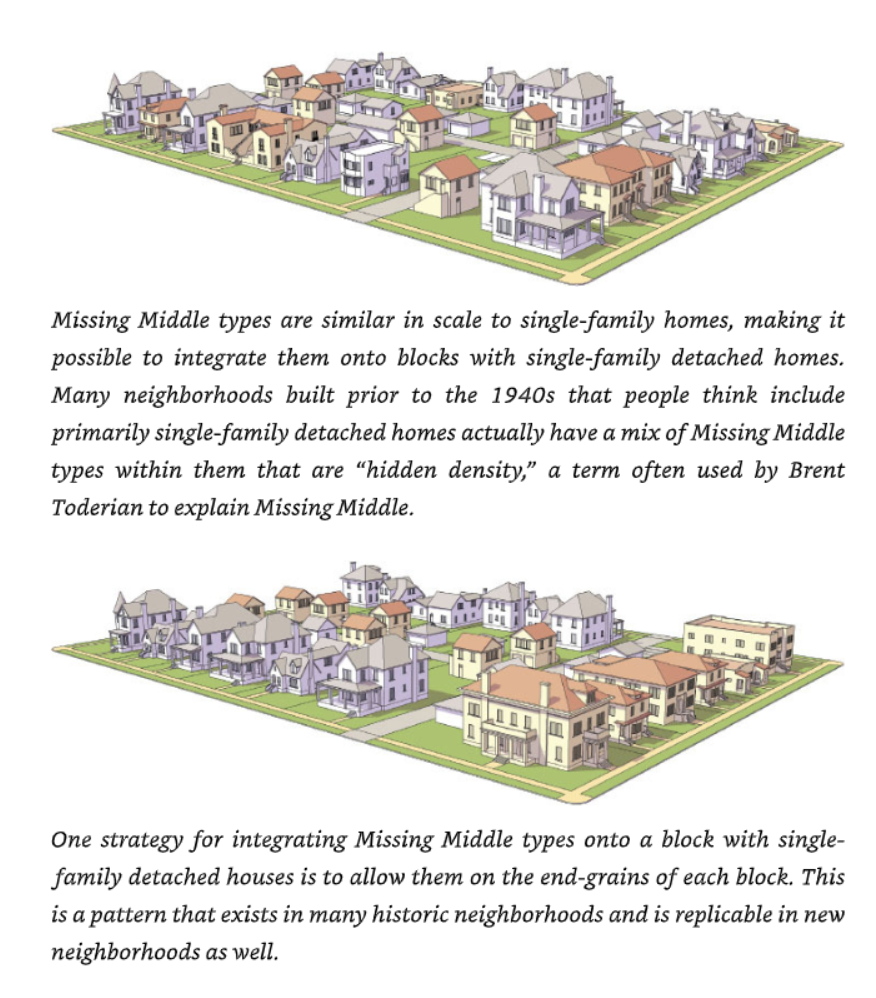
Missing Middle Integration with Single Family Homes
from the Missing Middle Housing book - page 27
The first of the two diagrams above is the one that is most relevant to Newton. This is because: It is already the case in the proposed MRT zoning in VCOD Version 2 that MRT zones overlay existing Single Residence (SR) districts.
Therefore, it is extremely important to consider how the MRT zoning [that will be adopted on a lot by lot basis] will integrate with single family homes on adjacent lots. The first of the two diagrams above illustrates this integration. As Parolek says:
Missing Middle types are similar in scale to single-family homes, making it possible to integrate them onto blocks with single-family detached homes. Many neighborhoods built prior to the 1940s that people think include primarily single-family detached homes actually have a mix of Missing Middle types within them that are “hidden density,” a term often used by Brent Toderian to explain Missing Middle.
The key phrase is: are similar in scale to single-family homes. If the multi-family homes are too large then they will be unwelcome. If the multi-family homes are too small in comparison to single-family homes then they will stick out by their very smallness. People will come to think of them as those tiny multi-family homes forced into the neighborhood by the MBTA Communities Law. This will not be a good outcome either.
This is why the adoption of Parolek’s recommendations on dimensional standards is so important. He has spent 20+ years working with communities to do smooth integration of multi-family homes into single-family neighborhoods. He has the experience to back his recommendations.
In order for missing middle housing to fit into a single residence district, it is important that the homes have good quality design and construction. In order to be affordable, these homes should not be too expensive. At the same time, these homes should not be designed and built with shortcuts that will make the homes look cheap and tacky. A balance must be struck between quality and cost.
Parolek believes this is exactly the the purpose of missing middle housing. He gives two definitions for middle.
- First, and most importantly, it represents the middle scale of buildings between single-family homes and large apartment or condo buildings.
- The second definition of middle relates to the affordability or attainability level. These types have historically delivered attainable housing choices to middle-income families without subsidies and continue to play a role in providing homes to the “middle income” market segment that typically straddles 60 percent to 110 percent average median household income, in new construction, for-sale housing.
The task for MRT zoning is to ensure good quality and reasonable cost within Parolek’s dimensional constraints discussed above. Design standards for MRT buildings will be very important. The recommendation of a list of specific building forms for MRT is an example of a design standard.
Parolek emphasizes that local constraints must be taken into account. The interaction between transit quality or the lack thereof and the need for parking requirements is one such constraint.
In Newton, the limitations of the intra-city public transit makes it extremely problematic to consider a zoning law for a residential district with no minimum parking requirements.
For the brief argument that supports a minimum parking requirement for MRT, see:
The MRT zoning decision on parking should be:
- MRT zoning should require a minimum of one car parking space per housing unit in each home.
Additional parking requirements:
- Parking should be located at the rear of the house.
- Newton parking dimensional standards should apply:
-
- Normal stall width should be 9 feet.
- Handicap stall width should be 12 feet (if provided).
- Stall depth should be 19 feet.
- Assuming 90° head-in parking, the maneuvering aisle depth should be 24 feet.
- Driveway width should be 12 feet, which assumes one way movement when in use.
Here is the parking area required in the simplest geometry which is a row of 4 cars plus maneuvering space next to this row.
Row width = 9 + 9 + 9 + 12 = 39 feet, to allow for one handicap stall.
Parking depth = 19 + 24 = 43 feet.
Parking area = 39 x 43 = 1677 SF.
To the parking area, one must add the driveway area which is the width of 12 feet times the distance needed reach the parking area. Playing with the geometry may somewhat reduce the total area needed.
Mellow Zoning for MRT - Summary Conclusions
It has been my intention to convince the Newton City Council, the Zoning and Planning Committee, the members of the Planning Dept, the Mayor, the general residents of Newton, and the residents who live in the 5 half mile circles at Newton Centre, Newton Highlands, Eliot, Waban, and Woodland that MRT zoning can be the solution to the question of how to implement the MBTA Communities Law in Newton.
I have based my recommendations for MRT zoning on the ideas of Daniel Parolek on Missing Middle Housing. Parolek’s ideas are not a new theory tested nowhere. Parolek and his company Opticos Design have worked on these ideas for 20+ years and have helped many communities to implement them.
I have selected the housing form options from Parolek’s list to come up with those options that fit the Newton constraint of 3 or 4 units for new development and fit the MBTA Law constraints. To remind you, these housing forms are:
- The Traditional 2.5 Story House with Pitched Roof
- Fourplex houses
- A Pair of Stacked Duplex houses
- A Pair of Side-By-Side Duplex houses
-
- perhaps with one duplex in front and one duplex in back
- perhaps with the duplex buildings facing each other across an open courtyard
- A Courtyard Building, with 3 or 4 units
It is my fervent hope that each one of these forms would be acceptable to Newton residents if they were used to build a house on the lot next door.
The question of footprint size is also important. Parolek recommends 3600 SF. This footprint is entirely consistent with the current sizes of smaller 2-family homes now being built in Newton. This footprint will result in houses that are not too large and not too small. So, both in terms of form and size, new MRT construction will fit in.
Of course, the MRT zoning proposals are also designed to incentivize renovations with additions. In that case, the original building is there so that there is no question that the building will fit in.
Separated from the current complexities of VCOD, it will actually be easier to design and implement MRT zoning as a standalone entity. There is still substantial controversy about VCOD, so implementation of the MBTA Communities Law zoning via VCOD will actually be more difficult.
In the section below
I give a complete recipe with maps for how to construct a backbone path that will pass through the main streets of the 5 Half Mile Circles area and allow most residential lots in that area to be reached. This will guarantee a very large contiguous area.
Let me explain why such a large area is actually beneficial to the 5 Half Mile Circles residents.
The changes enabled by MRT will happen on a lot by lot basis. Here are some scenarios:
- An owner may ask a developer to convert their house to multi-family usage.
- An owner may decide to sell, in which case:
-
- The new owner may keep the house as is.
- The new owner may ask a developer to convert the house to multi-family usage.
- The new owner may ask a developer to replace the house with a new 3 or 4 family house.
- The new owner may be a developer who has to decide what to do.
In all of these cases, the developer will likely be a small developer who specializes in single projects. Large development corporations want to do mega-projects and do not want to do projects on small lots.
The consequences of these scenarios are that the larger the area that is MRT enabled the more likely it is that development change will be randomly diffused throughout the larger area. This randomization is a protection for the individual homeowner because it is unlikely that many changes will happen nearby.
I hope that the above explanations and arguments will convince everyone that using MRT zoning in the 5 Half Mile Circles area is the way to go to implement MBTA Communities Law zoning.
Additional MRT Recommendations
- Newton zoning should explicity call attention to the following housing forms as options for MRT:
-
- The Traditional 2.5 Story House with Pitched Roof
- Fourplex houses
- A Pair of Stacked Duplex houses
- A Pair of Side-By-Side Duplex houses
-
- perhaps with one duplex in front and one duplex in back
- perhaps with the duplex buildings facing each other across an open courtyard
- A Courtyard Building, with 3 or 4 units
- This list will make the MRT zoning somewhat more ”form based” and not just ”dimension based”.
- In MRT, new construction should satisfy one of the following two dimensional constaints:
-
- Maximum width is 55 FT and maximum depth is 65 FT.
- Maximum footprint is 3600 SF.
- This allows the city to indicate the preferred width by depth sizes but allows a developer to get a similar amount of footprint area if the lot does not permit the ideal rectangular shape.
- In MRT, new construction should have:
-
- Maximum height of 2.5 stories.
- Either 3 or 4 housing units.
- In MRT, the option of renovations with additions should satisfy:
-
- From 3 to 6 housing units.
- Maximum footprint is the existing footprint or 4500 SF, whichever is larger.
- The footprint rule represents a 25% increase over what is allowed for new construction.
- MRT zoning should require a minimum of one car parking space per housing unit in each home.
- Parking should be located at the rear of the house.
- Newton parking dimensional standards should apply:
-
- Normal stall width should be 9 feet.
- Handicap stall width should be 12 feet (if provided).
- Stall depth should be 19 feet.
- Assuming 90° head-in parking, the maneuvering aisle depth should be 24 feet.
- Driveway width should be 12 feet, which assumes one way movement when in use.
Mini-Appendix: MRT Parking Calculations
General Rules for Driveway
- Driveway area is 12 x (driveway length).
- The driveway length depends on the front setback, the house depth, and how much extra length is needed to enter the parking area (if any).
Scenario 1: New construction
Assume 4 parking spaces for 4 housing units. Assume one handicap space.
This implies:
- Width for 4 stalls = 9 + 9 + 9 + 12 = 39 feet.
- Depth for the stalls and the aisle = 19 + 24 = 43 feet.
- Minimum required parking area= 39 x 43 = 1677 SF.
Assume front setback = 10 feet and house depth = 65 feet. Driveway feeds directly into parking.
This implies:
- Minimum required driveway area = 12 x (10 + 65) = 12 x 75 = 900 SF.
Thus:
Total of parking + driveway area = 1677 + 900 = 2577 SF.
(Total of parking + driveway area) / (Maximum footprint) = 2577 / 3600 = 72%.
Scenario 2: Renovation with additions
Assume 6 parking spaces for 6 housing units. Assume one handicap space.
This implies:
- Width for 4 stalls = 9 + 9 + 9 + 9 + 9 + 12 = 57 feet.
- Depth for the stalls and the aisle = 19 + 24 = 43 feet.
- Minimum required parking area = 57 x 43 = 2451 SF.
Assume front setback = 10 feet and house depth = 80 feet. Driveway feeds directly into parking.
This implies:
- Minimum required driveway area = 12 x (10 + 80) = 12 x 90 = 1080 SF.
Thus:
Total of parking + driveway area = 2451 + 1080 = 3631 SF.
(Total of parking + driveway area) / (Maximum footprint) = 3631 / 4500 = 81%.
Parking Conclusions
As the Planning Dept is well aware, parking and driveway area adds substantially to the area required on a lot for multi-family housing.
I still support the parking requirements that I have proposed because the transit we have in reality in Newton is not adequate to support families with children.
The Large Contiguous MRT District in the 5 Half Mile Circles
The most difficult aspect of MBTA Compliance turns out to be to design a large zoned district of contiguous lots that contains at least 50% of all the area being zoned for MBTA approval in Newton. It is the purpose of this section to show a flexible way to accomplish this task. Keep in mind:
For Newton, due to the 90% rule, the large contiguous district with at least 50% of all zoned area must fall into an overlapping chain of half mile circles around transit stations.
Section Contents:
- The 11 Half Mile Circles at Rail Transit Stops in Newton
- The 5 Half Mile Circles for the Large Contiguous MRT District
- 16 Contiguous Backbone Paths in the 5 Half Mile Circles
- The Large Contiguous MRT District and the Completion of MBTA Communities Zoning
The 11 Half Mile Circles at Rail Transit Stops in Newton
I will discuss which half mile circles may be used to create one large contiguous district of zoned area that is 50% of all zoned area.
If you examine the map above, you will see that there is a chain of 7 overlapping circles: Newton Centre, Newton Highlands, Eliot, Waban, Woodland, Riverside, and Auburndale.
To explain why not all 7 of these circles may be used together, I must speak of the Newton Historic Districts. When the maps for VCOD Version 1 were released, residents of Newton Upper Falls and Newtonville noticed that portions of their historic districts were included in VCOD zones. These residents objected. After consideration, the Planning Dept decided to exclude all Newton Historic Districts from future VCOD zoning maps.
The 4 Newton Historic Districts are Auburndale, Chestnut Hill, Newton Upper Falls, and Newtonville. The Auburndale Historic District effectively blocks a residential VCOD zone-able path from the Woodland half mile circle that goes deep into either the Auburndale half mile circle or the Riverside half mile circle.
However, if you compare the map of the Auburndale Historic District with the map of the Woodland half mile circle, you can see there are a significant number of residential lots in the immediate area close to Washington St and Aspen Ave that fall within the Woodland half mile circle and that may be VCOD zone-able as MRT.
Therefore, the task will be to see how to create one large contiguous MRT district within the 5 half mile circles centered at: Newton Centre, Newton Highlands, Eliot, Waban, and Woodland.
The 5 Half Mile Circles for the Large Contiguous MRT District
Here is an image of the 5 half mile circles centered at: Newton Centre, Newton Highlands, Eliot, Waban, and Woodland.
The 5 Half Mile Circles
Here is an image of the current Newton zoning in the area of the 5 Half Mile Circles.
Current Newton Zoning under the 5 Half Mile Circles
The next section will show how to create Contiguous Backbone Paths that form the heart of the proposed MRT zoning in the 5 Half Mile Circles.
16 Contiguous Backbone Paths in the 5 Half Mile Circles
Here is a summary of my approach to the task of creating one large contiguous MRT district within the 5 half mile circles: Newton Centre, Newton Highlands, Eliot, Waban, and Woodland.
- Step 1: Path Geometry
-
- I plan to define 16 backbone paths that spread throughout the area of the 5 half mile circles in such a way that many residential locations within the half mile circles are reachable from one or more of the 16 backbone paths via a sequence of adjacent residential lots that are separated at most by ordinary streets. I will call such a residential lot a reachable residential lot.
- Each backbone path will be one of two types:
-
- A major street path going along a residential portion of that street.
- A bypass route using several streets that gets around an obstacle such as a commercial center or a hospital.
- The 16 backbone paths will either touch or cross in such a way that the network of 16 paths will be contiguous. This will be obvious from the map images.
- Step 2: Zoning
-
- The 16 backbone paths will be zoned MRT on both sides of a street if possible and on one side only if necessary. This core MRT zoning will already reach a significant portion of Newton near 5 transit stops on the Green Line D Branch.
- The Planning Dept and Utile [using database tools that only they can access] may then spread MRT zoning into the residential neighborhoods adjacent to the 16 backbone paths by adding all reachable residential lots. This will create the large contiguous MRT district within the 5 half mile circles.
- The large contiguous MRT district should not cross Route 9 since at 70-80 feet in width that route is too wide a barrier.
The success of this idea depends on making MRT zoning palatable across Newton. That is precisely the purpose of the discussion in:
It is essential that the multi-family housing that is built under MRT fits in seamlessly with adjacent single-family housing.
Definition of the 16 Contiguous Backbone Paths in the 5 Half Mile Circles
Notes:
- You may wish to click on the image above so that it will open in a separate tab.
- This will let you see a wider version of the image and will let you zoom in to examine some details of the 16 backbone paths.
- Below I will show individual images of the 5 half mile circles so that you may see the 16 backbone paths in even higher resolution.
To give a precise definition of the 16 backbone paths, I will show individual images of each of the 5 half mile circles being studied: Newton Centre, Newton Highlands, Eliot, Waban, and Woodland.
These half mile circle maps will show the backbone paths that intersect that circle.
Underneath each half mile circle map, I will give the precise definition of each path.
If a path crosses two half mile circles, its definition is listed twice.
I believe that it is important that readers be able to see a list of all 16 backbone paths before getting into the details. This will allow people to see the 11 major streets and the 5 bypass routes.
The path names are actually links to the path definitions. This is nice for future reference but I think it is good idea to proceed linearly down this document the first time through.
List of the 16 backbone paths
- Path 1 Beacon St {Newton Centre} Length: 0.34 mile
- Path 2 Grant Ave {Newton Centre} Length: 0.29 mile
- Path 3 Bypass {Newton Centre} Length: 0.82 mile
- Bypass around Newton Centre commercial area
- Path 4 Centre St {Newton Centre & Newton Highlands} Length: 0.56 mile
- Path 5 Langley Rd {Newton Centre} Length: 0.41 mile
- Path 6 Cypress St & Parker St {Newton Centre} Length: 0.39 mile
- Path 7 Bypass #1 {Newton Highlands} Length: 0.32 mile
- Bypass around Newton Highlands commercial area - part 1
- Path 8 Walnut St {Newton Highlands} Length: 0.48 mile
- Path 9 Bypass #2 {Newton Highlands} Length: 0.24 mile
- Bypass around Newton Highlands commercial area - part 2
- Path 10 Lincoln St {Newton Highlands & Eliot} Length: 0.23 mile
- Path 11 Woodward St {Eliot & Waban} Length: 0.96 mile
- Path 12 Chestnut St {Waban} Length: 0.81 mile
- Path 13 Bypass {Waban} Length: 0.46 mile
- Bypass around Waban commercial area
- Path 14 Beacon St {Waban & Woodland} Length: 0.91 mile
- Path 15 Bypass {Woodland} Length: 0.45 mile
- Bypass behind Newton-Wellesley Hospital
- Path 16 Washington St {Woodland} Length: 0.50 mile
Summary data
- Total path length: 8.17 miles
-
- Major street path length: 5.88 miles
- Bypass route path length: 2.29 miles
Maps of the 16 Contiguous Backbone Paths in the 5 Half Mile Circles
I now proceed to show the maps of the 5 half mile circles with the backbone paths on each map. Each map is followed by the path definitions for those paths that intersect the map.
MBTA Contiguous Paths in Newton Centre
Path 1 Beacon St {Newton Centre} Length: 0.34 mile
- Beacon St & Bishopsgate Rd
- to Beacon St & Chesley Rd
Path 2 Grant Ave {Newton Centre} Length: 0.29 mile
- Beacon St & Grant Ave
- to Grant Ave & Montvale Rd
Path 3 Bypass {Newton Centre} Length: 0.82 mile
Bypass around Newton Centre commercial area
- Beacon St & Glen Ave
- to Glen Ave & Warren St
- to Warren St & Langley Rd
- to Langley Rd & Braeland Ave
- to Braeland Ave & Cypress St
- to Cypress St & Paul St
- to Paul St & Centre St
Path 4 Centre St {Newton Centre & Newton Highlands} Length: 0.56 mile
- Centre St & Paul St {in Newton Centre & Newton Highlands}
- to Centre St & Walnut St {in Newton Highlands}
Path 5 Langley Rd {Newton Centre} Length: 0.41 mile
- Langley Rd & Braeland Ave
- to Langley Rd & Madoc St
Path 6 Cypress St & Parker St {Newton Centre} Length: 0.39 mile
- Cypress St & Braeland Ave
- to Cypress St & Parker St
- to Parker St & Athelstane Rd
MBTA Contiguous Paths in Newton Highlands
The path below was listed above in Newton Centre
Path 4 Centre St {Newton Centre & Newton Highlands} Length: 0.56 mile
- Centre St & Paul St {in Newton Centre}
- to Centre St & Walnut St {in Newton Highlands}
Path 7 Bypass #1 {Newton Highlands} Length: 0.32 mile
Bypass around Newton Highlands commercial area - part 1
- Centre St & Hyde St
- to Hyde St & Lake St
- to Lake St & Walnut St
Path 8 Walnut St {Newton Highlands} Length: 0.48 mile
- Walnut St & Lake St
- north on Walnut St to the half mile circle boundary
Path 9 Bypass #2 {Newton Highlands} Length: 0.24 mile
Bypass around Newton Highlands commercial area - part 2
- Walnut St & Forest St
- to Forest St & Chester St
- to Chester St & Lincoln St
Path 10 Lincoln St {Newton Highlands & Eliot} Length: 0.23 mile
- Lincoln St & Chester St
- to Lincoln St & Woodward St
For Path 11, see Eliot below.
MBTA Contiguous Paths in Eliot
The path below was listed above in Newton Highlands
Path 10 Lincoln St {Newton Highlands & Eliot} Length: 0.23 mile
- Lincoln St & Chester St
- to Lincoln St & Woodward St
Path 11 Woodward St {Eliot & Waban} Length: 0.96 mile
- Woodward St & Erie Ave {Eliot}
- to Woodward St & Pine Ridge Rd {Waban}
MBTA Contiguous Paths in Waban
The path below was listed above in Eliot
Path 11 Woodward St {Eliot & Waban} Length: 0.96 mile
- Woodward St & Erie Ave {Eliot}
- to Woodward St & Pine Ridge Rd {Waban}
Path 12 Chestnut St {Waban} Length: 0.81 mile
- Chestnut St & Oliver Rd
- to Chestnut St & Oakvale Rd
Note: Chestnut St crosses Woodward St
Path 13 Bypass {Waban} Length: 0.46 mile
Bypass around Waban commercial area
- Chestnut St & Fenwick Rd
- to Fenwick Rd & Collins Rd
- to Collins Rd & Beacon St
Path 14 Beacon St {Waban & Woodland} Length: 0.91 mile
- Beacon St & Collins Rd {Waban}
- to Beacon St & Washington St {Woodland}
MBTA Contiguous Paths in Woodland
The path below was listed above in Waban
Path 14 Beacon St {Waban & Woodland} Length: 0.91 mile
- Beacon St & Collins Rd {Waban}
- to Beacon St & Washington St {Woodland}
Path 15 Bypass {Woodland} Length: 0.45 mile
Bypass behind Newton-Wellesley Hospital
- Beacon St & Dorset Rd {near Newton-Wellesley Hospital}
- north on Dorset Rd about 730 FT to footpath behind Newton-Wellesley Hospital
- footpath to Longwell Rd
- Longwell Rd to Longfellow Rd
- to Longfellow Rd & Washington St
Path 16 Washington St {Woodland} Length: 0.50 mile
- Washington St & Longfellow Rd
- to Washington St & Seton Hill Rd
Let me comment on the current zoning on Washington St between the two places where Washington St meets Stanton Ave. This section is between 2 golf courses. The Woodland Country Club is to the west and the Brae Burn Country Club is to the east. The 2 golf courses are zoned Single Residence 1 (SR1) even though there are no residential houses on the golf courses. The section of Washington St somehow “inherited” the SR1 zoning from being adjacent to the golf courses. By examining the assessor's database, I learned that there are two 3-family homes on the section. Therefore, it appears that SR1 is not an accurate zoning designation. That is why I considered it appropriate to use MRT as an overlay along this section of Washington St.
The Large Contiguous MRT District and the Completion of MBTA Communities Zoning
Between the original posting of this document and the subsequent posting of Revision #1, it became that two MBTA requirements needed to be considered:
- Meet the MBTA goal of 8330 enabled housing units in Newton
- Meet the MBTA requirement of a gross density of 15 enabled housing units per acre
We came to the conclusion that to solve these problems we needed to invent a modified zoning type discussed below:
To a substantial extent, the discussion there supercedes the discussion here.
We have, however, left the original text of this section as is.
At the completion of the work to create the Large Contiguous MRT District in the 5 Half Mile Circles, the Planning Dept will know the number N of residential lots that have been included in the district. Since the MBTA Communities Zoning in Newton assumes 4 housing units per MRT lot, the number of enabled MRT housing units H will be 4 times N. If H is greater than or equal to 8330, then the work of MBTA Communities Zoning will be done.
To me, it seems likely that: H ≥ 8330. However, if this is not the case, then additional districts with MRT residential lots will need to be included in the MBTA computation. These districts will not be contiguous with the Large Contiguous MRT District.
Here is the order that I recommend when seeking to define additional districts with MRT residential lots:
- Newton Centre - In the half mile circle, north and south of Beacon St between the Newton Centre Playground and Crystal Lake.
- This choice has the advantage that the area is within a half mile of the Green Line Newton Centre station.
- Newtonville - The Version 2.0 MRT district in Newtonville has two contiguous MRT districts south of the turnpike, one area west of Walnut St and one area east of Walnut St. These areas probably meet the MBTA minimum 5 acre requirement and so do not need to be expanded.
- This choice has the advantage that Bus 59 connects to the Green Line Newton Highlands station.
- Auburndale - If the Version 2.0 MRT district in Auburndale needs to be expanded then go west from Ash St between Auburn St and Commonwealth Ave while remaining in the Auburndale half mile circle.
- This choice has the advantage that the area is a walk of less than a mile to the Green Line Riverside station.
- Newton Corner - Although Newton Corner is not near a rail transit stop, it has a Version 2.0 MRT district around Church St that probably meets the MBTA minimum 5 acre requirement and so does not need to be expanded.
- I do not include West Newton because it has a tiny MRT area and, given the massive amount of VC3 and VC2 zoning, should not have any additional zoning.
MRT-A = MRT plus the Ability to have Small Apartment Buildings
An additional zoning type to assist in the Completion of MBTA Communities Zoning
When I posted the original version of this discussion on VC zoning, MBTA zoning, and the role of MRT in the 5 half mile circles centered at the T stops of Newton Centre, Newton Highlands, Eliot, Waban, and Woodland, my main concern was:
Can my MRT based plan achieve the MBTA goal for Newton of 8330 enabled housing units?
More than one city councilor pointed out to me that with a maximum of 4 housing units per lot, it might not be possible to meet another MBTA requirement:
The minimum gross density of enabled housing units per acre must be at least 15 units per acre.
Naively, I thought that with 4 housing units on a 10000 SF lot and 4 such lots in an acre (43560 SF), there would be no problem with attaining 15 units per acre on average. However, the MBTA compliance tool counts the area of the roads in a zoned district. This acts to decrease the ratio of units per acre thus calling into question whether the desired MBTA ratio of 15 units per acre can be achieved with MRT alone.
It is the purpose of this section to introduce a sub-zone of MRT named MRT-A for
MRT with Small Apartment Buildings
that will allow small apartment buildings at select locations close to T stops and that will therefore permit more housing units to be built in the 5 half mile circles to achieve the goal of 8330 enabled housing and permit the MBTA gross density goal of 15 enabled housing units per acre to be achieved on average.
In this section, I introduce MRT-A which stands for MRT with Small Apartment Buildings. The first rules are:
- MRT-A is a sub-zone of MRT in the sense that any buildings that may be created by new construction or by renovation and addition under MRT zoning may also be created in MRT-A.
- MRT-A is different from MRT in that small apartment buildings of 4 stories in height and from 8 to 24 housing units may be created in MRT-A.
It is fruitful to begin with the special case:
A small apartment building of 4 stories in height with 8 housing units
Let me explain how this house fits into the context of MRT as described above. One of the housing types recommended by Daniel Parolek is the fourplex type which has 2 housing units on floor 1 and 2 housing units on floor 2 [a fourplex has 2 stories]. Now imagine that with the same footprint, we add 2 additional stories. Then we may also get 2 housing units on floor 3 and 2 housing units on floor 4. This gets us to an eightplex or 8-plex with a total of 8 housing units.
The maximum footprint of a fourplex in MRT is the same as for all MRT housing forms, namely, 3600 SF. Thus, we may state the special case of eightplex as:
- MRT-A will permit a small apartment building of 4 stories in height with 8 housing units and with a maximum footprint of 3600 SF.
If we came to a stop right here, MRT-A would already provide an option for doubling the enabled housing density in select locations. The potential options for more apartments in a building will simply provide more flexibility. In any case, what will be true is:
For the purposes of MBTA Compliance, MRT-A zoning may be considered to allow a minimum of 8 enabled housing units per lot.
I will now suggest the maximum footprint rules for a larger number of housing units in MRT-A.
- MRT-A will permit small apartment buildings of 4 stories in height with the following constraints:
-
- 8 units - maximum footprint: 3600 SF
- 9-12 units - maximum footprint: 5400 SF
- 13-16 units - maximum footprint: 7200 SF
- 17-20 units - maximum footprint: 9000 SF
- 21-24 units - maximum footprint: 10800 SF
- 8 units is the minimum number of units in an apartment building in MRT-A
- 24 units is the maximum number of units in an apartment building in MRT-A
What I have done to create these maximum footprint numbers is to increment by 1800 SF in each step. Incrementing the maximum footprint in this fashion means, for example, that three 8-plex buildings, two 12-plex buildings, and one 24-plex building all have the same maximum footprint (10800 SF). A developer of 24 units of housing may choose the best building configuration for a project without concern for the maximum footprint.
I feel that it is best to be generous with maximum footprint numbers and thus avoid the need for special permits for proposals that would otherwise be quite reasonable.
It is certainly the case that to achieve apartments with a larger number of housing units it will sometimes be necessary to combine lots. It is my hope that the city would permit this lot combination when the building plans make sense. From a developer standpoint, building one 24 unit apartment building on a lot combined from 3 lots may be more efficient than building 3 eightplex apartments on the 3 individual lots. Further, there is likely to be more usable open space as an extra benefit.
I would also hope that the zoning would encourage more interesting shapes for larger apartment buildings, such as buildings with courtyards.
Let me now discuss the location for MRT-A zoning. The first rule is derived from the definition of MRT-A as a sub-zone of MRT.
MRT-A zoning may be an overlay district on top of the following current zones:
- Single Residence 2 (SR2)
- Single Residence 3 (SR3)
- Multi Residence 1 (MR1)
- Multi Residence 2 (MR2)
- Multi Residence 3 (MR3)
Since MRT-A zoning doubles the density of MRT zoning, I make the following recommendation:
- MRT-A zoning should be limited to areas one quarter of a mile from transit stations.
At some point, the Planning Dept might have a good reason to override this geographic restriction but such a change should be done in a thoughtful manner.
I next adapt the parking parking requirements for MRT-A almost verbatim from the MRT discussion above. Families with children will have exactly the same needs for a car and parking in MRT-A as in MRT.
The MRT-A zoning decision on parking should be:
- MRT-A zoning should require a minimum of one car parking space per housing unit in each home.
Additional parking requirements:
- Parking should be located at the rear of the house.
- Newton parking dimensional standards should apply:
-
- Normal stall width should be 9 feet.
- Handicap stall width should be 12 feet (if provided).
- Stall depth should be 19 feet.
- Assuming 90° head-in parking, the maneuvering aisle depth should be 24 feet.
- Driveway width may be 12 feet, which assumes one way movement when in use, or may be 20 feet, which permits two way movement when in use.
- Two way movement may be the better choice for apartment buildings.
In the case of an eightplex, here is the parking area required in the simplest geometry which is 2 rows of 4 cars plus maneuvering space in between these rows.
Row width = 9 + 9 + 9 + 12 = 39 feet, to allow for one handicap stall.
Parking depth = 19 + 24 + 19 = 62 feet.
Parking area = 39 x 62 = 2418 SF.
To the parking area, one must add the driveway area which is the width of 20 feet times the distance needed reach the parking area. Playing with the geometry may somewhat reduce the total area needed.
Since an MRT-A apartment building is similar to a Village Center building of 3.5 stories, let me adapt to MRT-A some recommendations made in the next section:
The next section was actually written before this section.
Here are some recommendations on accessibility in MRT-A.
- An MRT-A apartment building should be wheelchair accessible from the front of the building at ground level.
- In an MRT-A apartment building, there should be both internal stairs and an internal elevator to reach the upper floors.
Here are some recommendations on solar panels and equipment in MRT-A.
- An MRT-A apartment building may have 8 feet of additional height so that solar panels and equipment may be installed on the roof above the top internal floor of the building.
- If an MRT-A apartment building takes advantage of this option then there must be attractive screening of the solar panels and equipment so none of this is visible from street level or from adjacent buildings of similar height.
Using MRT plus MRT-A to assist in the Completion of MBTA Communities Zoning
The question of whether or not the combination of MRT plus MRT-A may be used to meet all requirements for MBTA Compliance is data question that can only done by using:
- The MBTA Compliance tool
- The sophisticated Newton property database and map making tools that are only available to the Assessor’s Office and the Planning Dept.
No human being can simply eyeball the static maps of current zoning and the equally static maps of the 5 half mile circles to determine what lots may be zonable as MRT, how many such lots there are, how many housing units are enabled, and at what density of housing units per acre on average. No human being can simply eyeball the more subtle task of zoning for MRT-A in the quarter mile circles that will provide the doubling of housing density that will move the needle towards MBTA Compliance.
The data must be run systematically.
Part 1: Studying the 5 half mile circle area
Step 1: Determine the lots in the 5 half mile circles that may be used for MRT zoning
This entails:
- 1A: Determine the residential lots in the 5 half mile circles that are north of Route 9
- 1B: Determine the subset of these residential lots that are zoned SR2, SR3, MR1, MR2, MR3
- 1C: Determine the subset of this subset that can reach the backbone path discussed above
- The lots in 1C will form a large contiguous block that I will call the Large Contiguous Block
Technical Note: The backbone path is made up of 16 sub-paths. Path 16 along Washington St between Longfellow Rd and Day St contains a stretch zoned as SR1. The zoning is problematic since there are two buildings zoned SR1 that actually have 3 housing units. The SR1 zoning appears to come from the the zoning of the two nearby golf courses as SR1 not from what is on Washington St itself. I would recommend overriding SR1 in this stretch of Washington St. If that cannot be done in the data systems then ignore Path 16 in the backbone path.
Step 2: Consider the Large Contiguous Block as a zoning district for MRT.
Do the following data tasks:
- Create a map that shows the boundary of the Large Contiguous Block {hopefully the map will be zoomable}
- Determine the area A in acres of the Large Contiguous Block
- Determine the number N of lots in the Large Contiguous Block
- Determine the number H of enabled housing units in the Large Contiguous Block:
- H = 4 x N
- Determine the gross density D in housing units per acre:
- D = H / A
- Generate a spreadsheet with a list of the lots in the Large Contiguous Block sorted alphabetically by street name and subsorted numerically by house number. The street name and house number should be in the first two columns. In addition to the street name and house number, the lot information should include the current zoning designation and the lot size in SF (in separate columns).
As a result of this step, we will know if we have reached 8330 housing units and reached a gross density of 15 housing units per acre.
If we have not not reached both goals, go to Step 3.
Step 3: Introduce MRT-A zoning into a subset of the Large Contiguous Block
Do the following data tasks:
- Determine the subset of lots in the Large Contiguous Block that are within one quarter mile of one of the 5 transit stations: Newton Centre, Newton Highlands, Eliot, Waban, and Woodland.
- Call this subset of lots the Quarter Mile Subset.
- Note that the Quarter Mile Subset will not be contiguous since the 5 quarter mile circles do not intersect.
- Zone the Quarter Mile Subset as MRT-A.
- Create a map that shows the boundary of the Quarter Mile Subset {hopefully the map will be zoomable}
- Determine the number NQ of lots in the Quarter Mile Subset.
- Then (N - NQ) is the number of lots in the Large Contiguous Block not in the Quarter Mile Subset.
- Determine the number H1 of enabled housing units. Since MRT enables 4 housing unit per lot and MRT-A enables 8 housing unit per lot, the formula for H1 is:
- H1 = 4 x (N - NQ) + 8 * NQ = 4 x N + 4 * NQ = H + 4 * NQ
- Determine the gross density D1 in housing units per acre:
- D1 = H1 / A = (H + 4 * NQ) / A = H / A + 4 * NQ / A = D + 4 * NQ / A
- These two formulas show the incremental benefit of MRT-A zoning in the Quarter Mile Subset
- 4 * NQ is the incremental increase in housing units
- 4 * NQ / A is the incremental increase in housing density
As a result of this step, we will know if we have reached 8330 housing units and reached a gross density of 15 housing units per acre.
If we have reached both goals and have gone substantially past them then it will make sense to back off by removing MRT-A zoning from some lots. Looking at the actual value of NQ, we may figure out how many lots we may remove and still meet the MBTA Compliance requirements. The map of the Quarter Mile Subset will help with the decision of what lots to remove.
If we have not reached both goals, go to Step 4.
Step 4: Consider the alternatives for the Completion of MBTA Communities Zoning
Option 1: Use MRT and MRT-A in the half mile circles around other transit stations in Newton
I will go through the other 6 transit stations in the Newton either to dispose of them quickly or state what seems possible and what tradeoffs might be made.
- Chestnut Hill
In moving to VCOD Version 2, the Planning Dept made a rule that Historic Districts would not be subject to zoning. As you can see by comparing the half mile circle map with the historic district map, close to 100% of the residential area in the Chestnut Hill half mile circle is in the historic district.
Hence, Chestnut Hill is off the table.
- Boston College
The half mile circle map shows that about 50% of the circle is in Brighton. A large part of the Newton portion of the half mile circle is part of the grounds and buildings of Boston College. Further land is taken up by two reservoirs {Newton Reservoir and Waban Hill Reservoir} and by the Newton Commonwealth Golf Course.
Nevertheless, there is a significant area within the half mile circle that is residential plus a private school. The primary zoning of the area is SR2. There is also some MR1. Most of the area is north of Commonwealth Ave but a small portion is south of Commonwealth Ave. Using Google Maps, the area size is about 3,000,000 SF = 68 acres. This size is well above the MBTA Communities Law threshold for a zonable district.
I propose that this residential/private-school area within the Boston College half mile circle be zoned with MRT and that the subset within a quarter mile of the transit stop be zoned MRT-A.
This is consistent with the proposals made for the zoning in the 5 half mile circles.
- Riverside
Riverside is off the table for zoning because:
- Riverside is itself slated for a massive development project.
- To the west is the Charles River.
- To the south is Route 128.
- To the east is the Woodland Golf Club.
- To the north is a small business district followed by the Auburndale Historic District.
Concerns about the commuter rail locations: Auburndale, Newtonville, and West Newton
I am concerned about Auburndale, Newtonville, and West Newton because as I have shown in my study of The Reality of Transit in Newton the commuter rail service in Newton is by far the worst on the Framingham / Worcester line and certainly ranks among the worst in all of Massachusetts.
I am loathe to suggest MRT and MRT-A zoning for these communities without seeing the Planning Dept make a significant reduction in the intense, dense VC zoning imposed on these areas by VCOD Version 2. Let me discuss this below.
- Auburndale
Given the facts that:
- Auburndale has been given some VCOD Version 2 zoning
- Auburndale did not come into the MBTA Compliance computation in VCOD Version 2
I recommend that there be no new MRT and MRT-A zoning in Auburndale.
Here is the number of MBTA Compliance housing units assigned to Newtonville and West Newton:
- Newtonville: 1400 housing units
- West Newton: 1850 housing units
The total is 3250 units which is enormous.
Since a substantial number of housing units should emerge in the 5 half mile circles, there should be no need for nearly this many housing units.
- Newtonville
Recommendations:
- Do not zone structures that have recently been built such as Trio and 28 Austin St. Leave these unzoned.
- Do not zone the Star Market. It is a mistake to demolish the one building that uses air space over the pike.
- Downzone all VC2 on the map to MRT-A with the exception of the VC2 that abuts Walnut St north of Washington Park.
- Then downzone all VC3 on the map to VC2.
- Then review all VC2 and consider if any additional VC2 should be downzoned to MRT-A.
- Examine all MRT and consider if any should be MRT-A.
- Consider if there should be any additional MRT and MRT-A on lots south of the pike that are not currently zoned.
- The combination of the above changes will make it turn out that the MRT and MRT-A lots south of the pike form a a contiguous district that crosses Walnut St. Submit this district for MBTA Compliance.
- West Newton
I was astonished when I first examined the West Newton VCOD Version 2 Zoning Map. The large amount of zoned area devoted to VC3 and VC2 is stunning. I decided to use Google Maps to find the areas of each zoning type and then compute percentages.
The result for West Newton is:
VC3: 64.8%
VC2: 16.1%
MRT: 19.1%
In particular, 80.9% of the zoned area is VC3 or VC2. In my opinion, this is way too much for any community.
The result of this zoning in West Newton would be that the heart of the village center of West Newton as it currently exists would be destroyed..
More detailed information is given in the following screen snapshot:
Recommendations:
- First, I support the recommendation of Councilor Malakie in a memo of August 18 2023 that certain areas in a known flood zone along Border St and Harvey St be removed from the zoning altogether. This is simply practical good sense.
- Do not zone the land for the Dunstan East project. This land is currently under a 40B process and zoning is irrelevant. Should the project status change, zoning might then be considered.
- Downzone all remaining VC2 on the map to MRT-A.
- Then downzone all remaining VC3 on the map to VC2.
- Then review all VC2 and consider if any additional VC2 should be downzoned to MRT-A or omitted.
- Given the excessive amount of the initial VC zoning, the goal at this point should be that the percentage of land being zoned as VC2 should be significantly reduced. In consultation with the community, the Planning Dept should choose what is most important to zone as VC2 and not simply zone everything that is plausible.
- Examine all MRT on the current map and consider if any should be upzoned to MRT-A.
- In consultation with the community, the Planning Dept should consider whether there should be additional MRT and MRT-A.
- In particular, south of the pike in West Newton, there are areas with SR2, MR1, and MR2 zoning so these areas might be considered for MRT and MRT-A overlay zoning. Is this desirable for the city and the community?
Option 2: Use moderate VC zoning for the Completion of MBTA Communities Zoning
If MBTA Communities Zoning cannot be completely satisfied by MRT and MRT-A zoning then the final gap should be filled with VC zoning.
The initial philosophy should be to solve the residential housing problems in the residential areas as far as possible. If you think about it: Families with children are not inclined to live in intense business areas. In such areas, where do the children play? This statement is borne out by the fact that Trio has few families with children.
So, if VC zoning is to be used to provide housing for families with children, then the zoning should be as moderate and mellow as possible. There must be a balance between the VC zoning business needs and the practical needs of families with children for a pleasant environment to live in where the children may thrive.
Final Thoughts on Village Center Zoning
This section on Village Center Zoning is exactly as is from the original posting of the document on August 17 2023. This section does not take into account the section inserted above:
Therefore when reading you should think of references to MRT as now references to “MRT and MRT-A”.
I want to take up anew the question of whether or not Newton should even have a VC3 zoning type. I will assume here that people have accepted the earlier arguments that the proposed Route 9 District should be eliminated and that the VC1 zoning type should be eliminated since it use has been limited to the Route 9 District by the Planning Dept. To put my cards on the table, let me state some recommendations.
- Eliminate VC3.
- Down-zone all VC3 areas on VCOD Version 2 maps to VC2.
- Then, rename VC2 as simply VC, so that the zoning discussion and code is clean.
Here are some recommendations on the variety that may happen in VC.
- VC zoning should have two subtypes:
-
- VC-R: VC purely residential.
- VC-M: VC with mixed-use business required on the ground floor.
- VC-M should have the following options on the upper floors:
-
- VC-M-R: VC-M with residential required on the upper floors.
- VC-M-B: VC-M with additional business spaces on the upper floors.
- This option allows for multi-story businesses such as food stores and clothing stores.
- This option also allows for a mini-mall with assorted small business.
- VC-M-S: VC-M with public facing professional services on the upper floors.
- This option allows for medical and dental offices, legal and tax preparation offices, computer and printer tech help services, and similar professional services.
- VC-M-NR: VC-M with no residential on the upper floors, that is, VC-M-B or VC-M-S.
- If an area is zoned VC with no subtype specified then both subtypes are permitted.
- If an area is zoned VC-M with no subtype specified then all four subtypes are permitted.
Here are some recommendations on accessibility in VC.
- A VC building should be wheelchair accessible from the front of the building at ground level.
- In a VC building, there should be both internal stairs and an internal elevator to reach the upper floors.
- If a VC building provides underground parking, there should be separate stairs and a separate elevator to access this parking. The parking stairs and elevator should not compromise internal building security.
Here are some recommendations on solar panels and equipment in VC.
- A VC building may have 8 feet of additional height so that solar panels and equipment may be installed on the roof above the top internal floor of the building.
- If a VC building takes advantage of this option then there must be attractive screening of the solar panels and equipment so none of this is visible from street level or from adjacent VC buildings of similar height.
Let me discuss the rationale for the elimination of VC3 and its down-zoning to VC2 which will then be renamed as VC. I will then also discuss the more specific recommendations.
The most fundamental rationale for the elimination of VC3 is that we do not need the amount of housing focused in village centers that was proposed before the consideration of the MBTA Communities Law.
Councilors Wright and Oliver have done a detailed data study and determined that, using the Planning Dept VCOD Version 2 zoning, the number of VCOD enabled housing units would be:
MBTA Units: 9963
Non-MBTA Units: 8004
Grand Total of Units: 17967
Some people might quibble about the data methodology but tweaks in the methodology cannot change the order of magnitude of the results. If Newton passes the current VCOD Version 2 zoning proposal, Newton will enable more than twice the number of housing units as the MBTA mandate of 8330 housing units. This makes no sense.
If my proposal for MBTA Communities Zoning based 100% on MRT is adopted then Newton will satisfy the intent of the MBTA Communities Law by gradual diffusion of multi-family housing in residential areas. Newton will then have even less need for intense dense zoning in the village centers that focuses on large apartment style living.
Either way, using the current VCOD Version 2 zoning proposal or my proposal for MBTA Communities Zoning based 100% on MRT, there is no need for the height of VC3 buildings. VC3 may be eliminated.
Going forward, let me assume that you accept my proposal for MBTA Communities Zoning that is based 100% on MRT. Let me explain the consequences for the zone VC.
The thrust of my second set of recommendations is that VC buildings do not need to be restricted to having only housing units on the upper floors. Having more options creates much greater flexibility. My recommendations encourage on the upper floors of VC buildings:
- housing units
- business uses
- professional services
All of these options are public facing and add to the vitality of a village center.
I hope that my third set of recommendations on accessibility are self evident. I think that it especially important for senior citizens that the VC buildings be fully accessible.
My fourth set of recommendations on solar panels and equipment are intended to:
- Incentivize the use of solar panels to help slow climate change.
- Incentivize the placement of equipment on the roof to free up more usable space in the building.
For these goals, I am willing to see 8 feet added to the total building height.
Let me now discuss building form and open space related to VC buildings In this context, let me remind you of the discussion:
I wish to extract some particular comments from this discussion:
There is a problematic sentence in the District Purpose of VC2 and VC3:
Buildings are typically set close to the sidewalk to create a defined street wall that supports pedestrian activity and a sense of place.
Why on earth do pedestrians in village centers need a street wall so that we will have a sense of place?
I think that, as pedestrians, we will know when we are in village centers and we do not need a canyon like street wall to tell us this.
The Planning Dept has used the following image to sell the concept of Vibrant Village Centers to the Newton community, both in the past and just before the public hearing of June 26:
This image shows an inset public plaza forming a courtyard with mixed use businesses wrapping around the edges of the plaza. The public plaza seems to be a really nice feature to have in a village center.
However, the concept of a street wall and the VCOD Version 2.1 zoning code that supports this idea effectively prohibits public plazas.
In the same Zoning Redesign Info Sheet from which the above image was taken, there is a page with the title Creating a Sense of Place Supports Businesses:
The Sense of Place is provided by the Bram Way public plaza which is just the kind of space that the VCOD Version 2.1 zoning code would prohibit.
The street wall concept is embedded in the VCOD Version 2.1 Zoning Ordinance of June 12 2023 on page 5. On this page, the front setback for VC2 and VC3 is set to zero, that is, the front of a VC building must line up the edge of the main sidewalk.
This does not allow for any chairs, tables, or benches in front of a VC building. This does not even allow people to step out of the way of walkers to stop and chat with one another. This is not people friendly.
I recommend:
- Eliminate the street wall concept.
- Set the front setback for VC to: 0 feet to 12 feet.
- This is intended to allow for one or two parallel rows of tables in front of a building or to allow for just chairs or benches via a smaller choice of setback.
- Permit a building to have positive setback on the ground level (as above) but also permit the building to have zero setback on the floors above.
- This is intended to allow for a covered seating area in front of a building that provides some protection during light rain.
- The upper stories of the building would in this situation be cantilevered.
There needs to be zoning to enable plazas. Without being specific, I recommend:
- Define zoning to enable plazas.
- The zoning rules should be flexible enough to permit what is shown in the Planning Dept slide:
- IMAGE: Zoning Redesign Info Sheet - Page 1
- Notice that the slide shows walkways, mixed-use businesses around the plaza, and a tree.
The zoning rules permit more than one building on a lot if overall space permits and there is 25 feet between the buildings. In some cases, it may be more attractive and useful to have a single larger building. I recommend:
- Define conditions in which a large single building might be allowed on a VC lot by special permit.
- One example of such a condition might be to use the space that might have been between buildings to create a plaza.
Additional Village Center Recommendations
- Eliminate VC3.
- Down-zone all VC3 areas on VCOD Version 2 maps to VC2.
- Then, rename VC2 as simply VC, so that the zoning discussion and code is clean.
- VC zoning should have two subtypes:
-
- VC-R: VC purely residential.
- VC-M: VC with mixed-use business required on the ground floor.
- VC-M should have the following options on the upper floors:
-
- VC-M-R: VC-M with residential required on the upper floors.
- VC-M-B: VC-M with additional business spaces on the upper floors.
- This option allows for multi-story businesses such as food stores and clothing stores.
- This option also allows for a mini-mall with assorted small business.
- VC-M-S: VC-M with public facing professional services on the upper floors.
- This option allows for medical and dental offices, legal and tax preparation offices, computer and printer tech help services, and similar professional services.
- VC-M-NR: VC-M with no residential on the upper floors, that is, VC-M-B or VC-M-S.
- If an area is zoned VC with no subtype specified then both subtypes are permitted.
- If an area is zoned VC-M with no subtype specified then all four subtypes are permitted.
- A VC building should be wheelchair accessible from the front of the building at ground level.
- In a VC building, there should be both internal stairs and an internal elevator to reach the upper floors.
- If a VC building provides underground parking, there should be separate stairs and a separate elevator to access this parking. The parking stairs and elevator should not compromise internal building security.
- A VC building may have 8 feet of additional height so that solar panels and equipment may be installed on the roof above the top internal floor of the building.
- If a VC building takes advantage of this option then there must be attractive screening of the solar panels and equipment so none of this is visible from street level or from adjacent VC buildings of similar height.
- Eliminate the street wall concept.
- Set the front setback for VC to: 0 feet to 12 feet.
- This is intended to allow for one or two parallel rows of tables in front of a building or to allow for just chairs or benches via a smaller choice of setback.
- Permit a building to have positive setback on the ground level (as above) but also permit the building to have zero setback on the floors above.
- This is intended to allow for a covered seating area in front of a building that provides some protection during light rain.
- The upper stories of the building would in this situation be cantilevered.
- Define zoning to enable plazas.
- The zoning rules should be flexible enough to permit what is shown in the Planning Dept slide:
- IMAGE: Zoning Redesign Info Sheet - Page 1
- Notice that the slide shows walkways, mixed-use businesses around the plaza, and a tree.
- Define conditions in which a large single building might be allowed on a VC lot by special permit.
- One example of such a condition might be to use the space that might have been between buildings to create a plaza.
Coda: A Summary of Important Points
The most important goals of writing this document are:
- Promote the solution of the MBTA Communities Zoning problem by:
-
- Using the MRT zoning type:
-
- MRT requires 3 to 4 housing units for new residential construction
- MRT permits 3 to 6 housing units when renovating existing residential buildings
- Using the MRT zoning type in the residential neighborhoods that are in close proximity to the MBTA Green Line stations.
- Improve the definition of the MRT zoning type by using the ideas of Daniel Parolek who is a world class expert on the seamless integration of multi-family homes into single family neighborhoods.
- Improve the definition of the VC zoning types to make them somewhat less intense and to permit them to have more options above the first floor of a mixed-use building than simply residential housing.
Of course, it is also necessary during the discussion to explain why the solution of the MBTA Communities Zoning problem by using VC zoning as the primary tool to achieve housing numbers turns out to be quite problematic. I will not however repeat the discussion in this summary.
After this document was posted on August 17 2023, I received feedback that my solution to the MBTA Communities Zoning problem might fail due to the lack of sufficient housing density (a technical requirement in MBTA Compliance). This led to an additional goal:
- Introduce a zoning type MRT-A which stands for: “MRT with Small Apartment Buildings”.
-
- MRT-A allows anything that MRT allows and in addition allows 4 story small apartment buildings with 8 to 24 apartments.
- MRT-A is effectively a purely residential transition from plain MRT to VC zoning.
- Use both MRT and MRT-A for the solution of the MBTA Communities Zoning problem.
The starting point for the use of MRT and MRT-A for the solution of the MBTA Communities Zoning problem is to spread this zoning in a careful manner into the 5 Half Mile Circles around the transit stops at Newton Centre, Newton Highlands, Eliot, Waban, and Woodland.
The “careful manner” by which the zoning will proceed is based on the following rules:
MRT zoning may be an overlay district on top of the following current zones:
- Single Residence 2 (SR2)
- Single Residence 3 (SR3)
- Multi Residence 1 (MR1)
- Multi Residence 2 (MR2)
- Multi Residence 3 (MR3)
MRT zoning may not be an overlay district on top of:
- Single Residence 1 (SR1)
In the 5 half mile circles, the MRT district will be constrained to form a large contiguous block.
In the 5 half mile circles, the MRT-A district will be constrained to fall within the quarter mile circles around the transit stations, that is, potential apartments will be close to the transit stations. This MRT-A subset district will not be contiguous.
I am well aware that the overlay of a single residence district by a multi-residence district is a great concern for many citizens of Newton.
Let me point out that the Planning Dept has set the precedent for using MRT to overlay SR2, SR3, MR1, MR2, and MR3 in its zoning of the large contiguous block from Newton Centre through Newton Highlands to the Route 9 area. Furthermore, by examining the existing Newton zoning, it becomes clear that the overlay of SR2 and SR3 by MRT is absolutely essential if Newton is to achieve MBTA Compliance. This overlay is not a mistake. However, the Planning Dept has not advertised that it is doing an overlay of SR2 and SR3 by MRT.
It has been my goal to use the precedent set by the Planning Dept to spread multi-family housing throughout the 5 half mile circle area and thus relieve the density pressures in the village centers.
It has also been my goal to use the ideas of Daniel Parolek, author of Missing Middle Housing, to make sure that the rules for MRT promote the seamless integration of multi-family housing into the neighborhoods. Parolek has the credibility of 20+ years of experience doing seamless integration. If you read the details of this proposal I think that you will realize that all will turn out OK.
This ends the big picture summary of my first main goal of spreading MRT throughout select areas in the city and thereby providing a solution to the MBTA Communities Zoning problem.
However, suppose that my first main goal is not accepted by the city:
I believe that the suggestions for MRT zoning and VC zoning stand alone and may significantly enhance the VCOD zoning that is currently being reviewed. Please take these suggestions seriously on their own merits.
From time to time, you may wish to consult the maps in these appendices:
Appendix: Village Center and Route 9 Proposed Zoning Maps Version 2
Note: You may click on each map to open in a separate tab. This may show a wider map.
Village Centers With VC2 and VC3
- Newton Corner Map Version 2
- Newtonville Map Version 2
- West Newton Map Version 2
- Auburndale Map Version 2
- Newton Centre Map Version 2
- Newton Highlands Map Version 2
- Thompsonville Map Version 2
Village Centers With VC2 Only
- Nonantum Map Version 2
- Four Corners Map Version 2
- Waban Map Version 2
- Newton Lower Falls Map Version 2
- Newton Upper Falls Map Version 2
Route 9
Planning Dept Large Contiguous MBTA District
- Planning Dept Large Contiguous MBTA District Version 2
- Current Newton Zoning Under Planning Dept Large Contiguous MBTA District
- Current Newton Zoning Legend
Village Centers With VC2 and VC3
Newton Corner Map Version 2
Newtonville Map Version 2
West Newton Map Version 2
Auburndale Map Version 2
Newton Centre Map Version 2
Newton Highlands Map Version 2
Thompsonville Map Version 2
Village Centers With VC2 Only
Nonantum Map Version 2
Four Corners Map Version 2
Waban Map Version 2
Newton Lower Falls Map Version 2
Newton Upper Falls Map Version 2
Route 9
Route 9 East Map Version 2
Route 9 West Map Version 2
Planning Dept Large Contiguous MBTA District Version 2
Current Newton Zoning Under Planning Dept Large Contiguous MBTA District
Current Newton Zoning Legend
Appendix: Half Mile Circle Maps at Rapid Transit & Commuter Rail T Stops
Green Line B Branch
Green Line D Branch
Commuter Rail
11 Half Mile Circles
Green Line B: Boston College
Green Line D: Chestnut Hill T
Green Line D: Newton Centre T
Green Line D: Newton Highlands T
Green Line D: Eliot T
Green Line D: Waban T
Green Line D: Woodland T
Green Line D: Riverside T
Commuter Rail: Newtonville T
Commuter Rail: West Newton T
Commuter Rail: Auburndale T
The 11 Half Mile Circles at Rail Transit Stops in Newtons
Appendix: Newton Historic Districts
The 4 Newton Historic Districts
- Auburndale Historic District
- Chestnut Hill Historic District
- Newton Upper Falls Historic District
- Newtonville Historic District
Auburndale Historic District
Chestnut Hill Historic District
Newton Upper Falls Historic District
Newtonville Historic District
